Voyages & Discovery
Orbis maritimi sive rerum in mari et littoribus gestarum generalis historia
Claude-Barthélemy Morisot · Dijon · Pierre Palliot · 1643
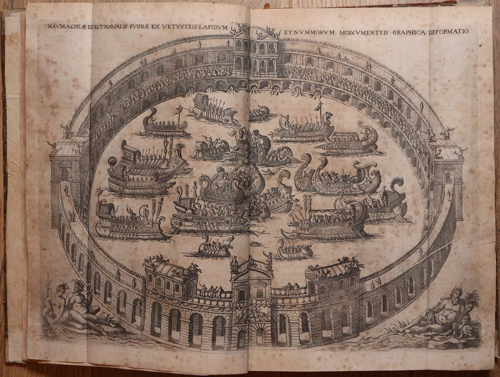
First and only edition of Morisot's encyclopaedic history of the sea, with 23 engraved maps, 11 ship illustrations and the large folding Roman Naumachia, with early Carthusian provenance.
FM-0219
€ 7.500
Key Properties
Edition: First and only edition
Format: Folio
Illustration: Additional allegorical engraved title, large folding engraved Naumachia, 44 engraved illustrations in the text including 23 maps, one full-page engraving
Provenance: Stamp CARTVSIAE VILLENOVAE on the title-page
Collation & Technical Description
A complete copy, retaining its extensive original cartographic and iconographic apparatus.
Additional allegorical engraved title.
Letterpress title printed in red and black. With the printed dedication to Chancellor Pierre Séguier, dated April 1643, on page 3.
The celebrated large folding engraved plate of a Roman Naumachia.
44 engraved illustrations in the text, including all 23 engraved maps.
Among the remaining engravings, all 11 representations of ships and other vessels, together with numismatic and other maritime subjects.
One full-page engraving.
The 23 maps in the present copy occur on pp. 198, 211, 217, 231, 244, 252, 257, 265, 279, 282, 284, 288, 294, 298, 315, 578, 581, 585, 586, 592, 601, 611 and 627.
The large folding Naumachia is preserved separately from the series of 23 maps.
Condition
A complete and well-preserved copy with the full cartographic and illustrative apparatus intact.
The paper remains generally sound with strong, crisp impressions. Some generally light to moderate toning and browning occurs throughout, in particular within the printed areas, while the broad margins frequently remain noticeably lighter and clean. A number of leaves show more pronounced foxing, principally marginal. Occasional further spotting and normal signs of age.
The maps and illustrations remain strongly printed and the substantial margins contribute considerably to the attractive overall appearance of the volume.
In an old half-leather binding over marbled boards, spine with raised bands and gilt-lettered label, showing the expected signs of age and use.
References & Bibliography
Sabin 50723; Borba de Moraes II, pp. 597–598; Alden & Landis, European Americana, 643/85; USTC 6810141; Shirley, Maps in the Atlases of the British Library, G.MORI-1a.
Description
An important and richly illustrated seventeenth-century history of the sea, generally regarded as the first comprehensive history of naval and maritime affairs.
Morisot's Orbis Maritimi is an ambitious encyclopaedic history of man's relationship with the sea, ranging from classical antiquity to the great European voyages of discovery. It encompasses navigation, shipbuilding, naval warfare, fleets, ports and colonies, maritime government and law, as well as geography and exploration.
The work is divided into two principal parts. The first is largely devoted to the maritime world of antiquity and includes the spectacular large folding engraving of a Roman naumachia, representing a staged naval battle. The second moves into the medieval and early-modern periods and discusses the maritime activities and discoveries of the principal European powers.
Of particular importance are Morisot's accounts of the voyages and discoveries associated with Columbus, Magellan, Gerrit de Veer, Walter Raleigh and the European exploration of the Americas, Africa and Asia. The geographical illustrations throughout the work encompass North and South America, Brazil, Tierra del Fuego, Africa, the Mediterranean, Asia and other regions.
Historical Significance
Morisot's Orbis maritimi has been described as the first comprehensive book on naval history, a veritable encyclopaedia of the maritime world, dedicated to Louis XIII. Its American chapters, on pp. 592 to 612, are illustrated with three maps, among them South America and Brazil, which is why the book has its place in Sabin, in European Americana and in Borba de Moraes' Bibliographia Brasiliana.
An unusually appealing complete copy of one of the earliest great encyclopaedic histories of the sea, preserving all 23 maps, all 11 ship illustrations and the spectacular folding Roman Naumachia, with distinguished early Carthusian provenance.
Provenance
An especially attractive feature of the present copy is the early institutional ownership stamp “CARTVSIAE VILLENOVAE” on the title-page. The stamp records an early Carthusian provenance associated with Villeneuve and is attributable to the Chartreuse Notre-Dame-du-Val-de-Bénédiction at Villeneuve-lès-Avignon, providing the volume with an appealing surviving witness to its early institutional history. The Chartreuse du Val de Bénédiction was founded in 1356 by Pope Innocent VI, who was buried in its church; it was suppressed at the Revolution and its library confiscated. The same ownership stamp, in the form “Cartusiae Villenovae”, is recorded in a book from this charterhouse now in the Bibliothèque municipale de Lyon.