Voyages & Discovery
Epitome cronicorum seculi moderni / Kurtzer Begriff der gedenckwurdigen Sachen (1500-1604)
MAYR, Johann (of Freising) · Munich · Nicolaus Henricus · 1604
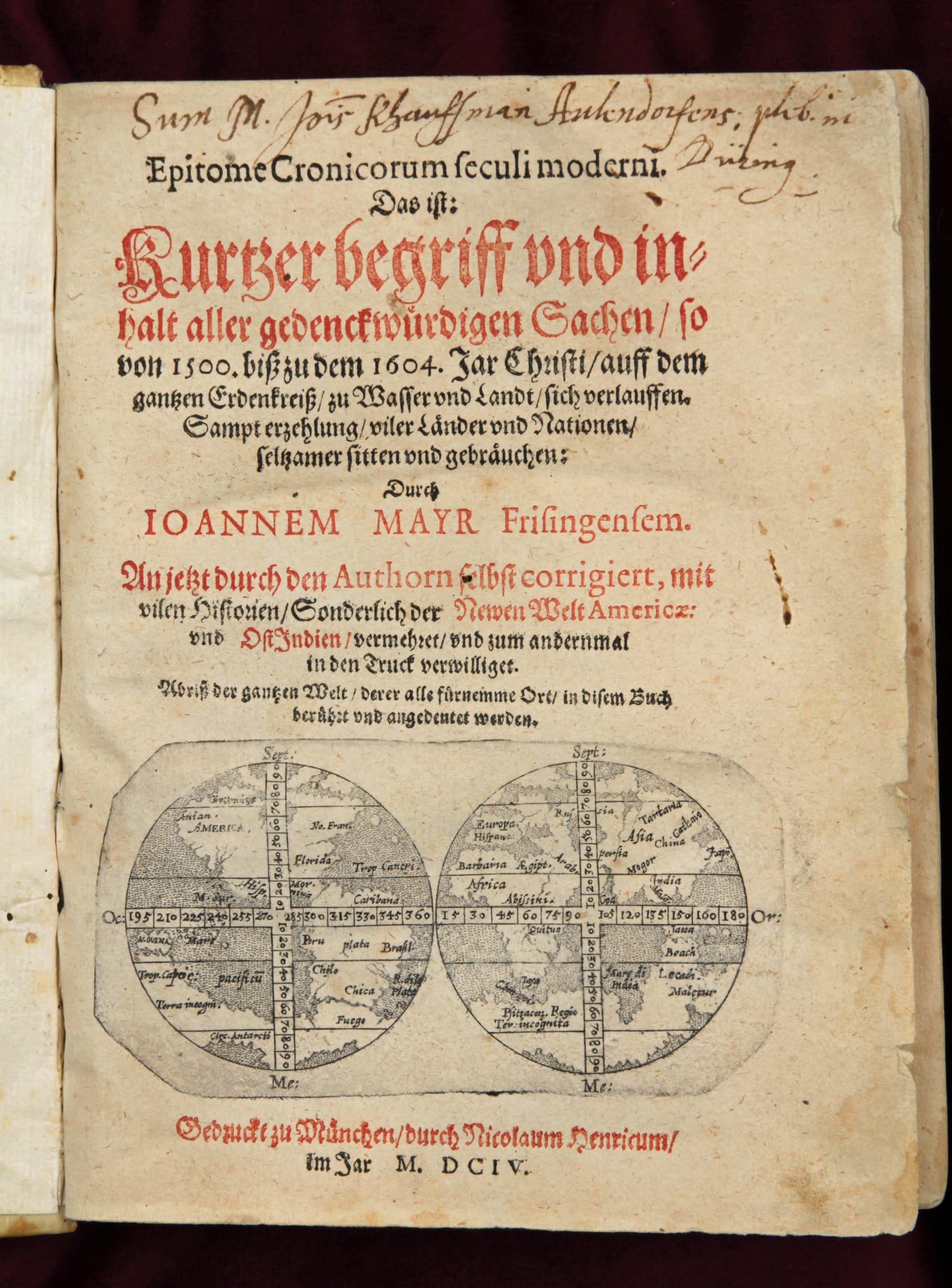
German world chronicle of 1500-1604 with the emphasis on Asia and the Americas, illustrated with an extremely rare little double hemisphere world map unseen by Shirley (his no. 245).
FM-0109
€ 3.200
Key Properties
Author: Johann Mayr of Freising
Title: Epitome cronicorum seculi moderni / Kurtzer Begriff der gedenckwurdigen Sachen
Place and printer: Munich, Nicolaus Henricus
Date: 1604 (second, enlarged edition; first 1598)
Format: 4to
Binding: Contemporary limp vellum
Language: German
Collation & Technical Description
4to. 4 unnumbered leaves; 340 leaves (the last blank). Engraved title page in black and red, with a small double hemisphere world map (7.5 x 14.5 cm), copper engraved.
Condition
Contemporary limp vellum.
References & Bibliography
Sabin 47110; European Americana 604/53; Shirley 245 (the map, recorded unseen); VD17 23:238362B.
Description
Second, greatly enlarged edition of the world chronicle of Johann Mayr of Freising, first published in 1598, here carried down to 1604 and printed at Munich by Nicolaus Henricus. Written in German, the Epitome treats the memorable events of the whole world year by year from 1500 to 1604, each year receiving a few pages. Europe is present but does not dominate: the emphasis falls on Asia and the Americas, drawn from Peter Martyr, Maffei and other Jesuit letters, Lopez de Gomara, and authors as recent as Jan Huygen van Linschoten.
The engraved title carries a small double hemisphere world map (7.5 x 14.5 cm) that repays close study. So rare is it that Shirley records the map as no. 245 without ever having seen a copy, and his standard reference work has no image of it. The prime meridian runs through Tenerife, and each hemisphere is quartered by a broad band along meridian and equator. Most remarkably, both poles are shown as open water surrounded by land and ice, a deliberate choice quite unlike the solid Terra Australis of Mercator, De Jode, Ortelius or Plancius; one wonders whether the source is Magellan himself, who heard the sea roaring on the far side of the land as he passed through his strait in 1520. The southern landmass, named Terra Incogni(ta), reaches north of the Tropic of Capricorn below New Guinea and Java, and carries the Polo-derived names Beach, Lecath and Maletur; Fuego lies below the Americas and the Psitacorum regio below Africa. Japan is robustly joined to China, and South America has the potato shape Mercator gave it in 1569. The major rivers of the world are shown, the unnamed Atrato in the Darien seeming to part North from South America, the old Spanish dream. The stippled oceans and fine italic lettering suggest an Italian hand, though Italy itself is nowhere shown on the map.
Historical Significance
A year-by-year chronicle of the age of exploration written as it happened, with the discoveries in Asia and the Americas at its heart, and illustrated with one of the rarest world maps of its day: a double hemisphere map whose open polar seas set it apart from every well-known world map of the period. Shirley knew of the map but never saw one.