Antique Maps
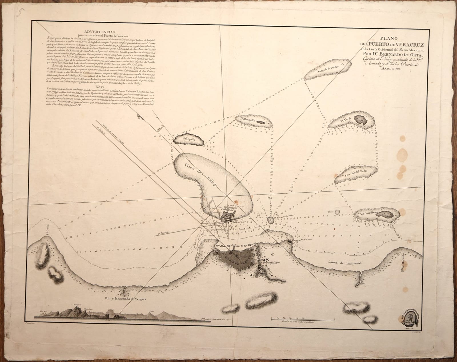
Plano del Puerto de Veracruz en la Costa Ocidental del Seno Mexicano
ORTA, Bernardo de; drawn by Felipe BAUZÁ, engraved by Fernando SELMA · Madrid · Depósito Hidrográfico · 1798
Bernardo de Orta's chart of the harbour of Veracruz, with the city, the fortress of San Juan de Ulúa, the reefs and islands of the approach, soundings, sailing directions and a coastal profile, published by the Spanish Hydrographic Office, Madrid 1798.
FM-0144
€ 1.050 VAT included (margin scheme)
Free insured shipping. The price shown is the price you pay.
Key Properties
Title: Plano del Puerto de Veracruz en la Costa Ocidental del Seno Mexicano. Por Dn. Bernardo de Orta, Capitan de Navio graduado de la Rl. Armada y de dicho Puerto. Año de 1798
Engravers: F. Bauzá fecit (lower left), F. Selma inc. (lower right)
Publisher: Depósito Hidrográfico, Madrid, with its emblem lower right
Technique: engraving, uncoloured
Contents: soundings, two leading lines for the entry, Advertencias (sailing directions) and Nota (depths, bottom, tides and currents), a coastal profile of the mountains inland, and a scale of one sea mile
Size: sheet 51.5 x 64.5 cm
Collation & Technical Description
Single sheet, engraved. Uncoloured. A pencil number "5" in the upper left margin. The sheet is not backed.
Sheet 51.5 x 64.5 cm.
Condition
Toned, with a vertical centre fold and some creasing. Several round brown stains in the right part of the image and in the left margin, and smaller spots elsewhere. Margins uneven, with creases at the edges.
References & Bibliography
Leventhal Map & Education Center, Boston Public Library, Plano del Puerto de Veracruz (1798)
Royal Museums Greenwich, Plano del Puerto de Veracruz (rmgc-object-542373)
Gazeta de Madrid, 31 July 1798, no. 61, p. 612 (advertisement of the chart)
Description
The chart covers the harbour of Veracruz and its approaches from the sea: the walled city of Veracruz on the shore, the island fortress of San Juan de Ulúa opposite it, and the reefs and islands that make the entrance dangerous, among them the Placer de la Gallega, Galleguilla, Isla Blanquilla, Isla Verde, Anegada de Dentro, Arrecife del Medio and Isla de Sacrificios. Soundings are given throughout, with the nature of the bottom.
In the upper left corner the Advertencias explain how to enter the harbour by two leading lines, first by bringing the tower of the church of San Francisco in line with the tower of the main church, then by lining up the bastions of San Crispín and San Pedro of the castle, and how to anchor. The Nota below explains that the depths are given in fathoms of two Castilian varas, the abbreviations for mud, gravel and stone, and the behaviour of the single daily tide and of the currents with the wind. At the foot is a profile of the mountains seen inland from the sea.
Historical Significance
Veracruz was the principal Atlantic port of New Spain, through which the trade between Mexico and Spain passed, and San Juan de Ulúa was its key fortress. Bernardo de Orta, captain of the port and a captain in the Spanish navy, surveyed it in the 1790s; the chart was drawn by Felipe Bauzá and engraved by Fernando Selma for the Depósito Hidrográfico in Madrid, the hydrographic office of the Spanish navy founded in 1797. Its sale was advertised in the Gazeta de Madrid of 31 July 1798.