Antique Maps
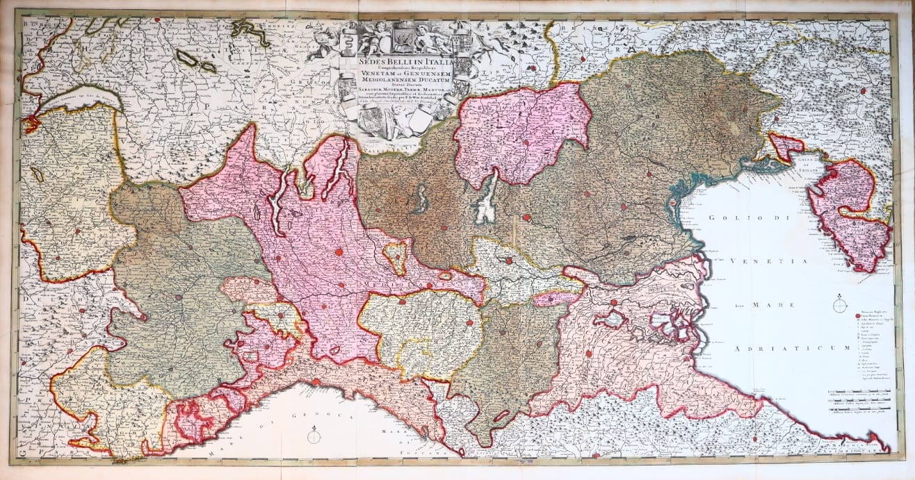
Lombardia quae Sedes Belli in Italia est
Frederik de Wit · Amsterdam · Frederik de Wit · c. 1700 to 1706
Frederik de Wit, monumental two-sheet map of Northern Italy as the theatre of war of the Spanish Succession, in early territorial hand-colour, Amsterdam c. 1700 to 1706; the early issue with De Wit's own imprint
FM-0151
€ 4.000
Key Properties
Edition: The early De Wit issue, with his own imprint and without the later Covens and Mortier imprint
Language: Latin
Format: Engraved map printed from two copperplates and joined, c. 100 x 54 cm
Colouring: Extensively hand-coloured in full territorial colour, contemporary or near-contemporary with publication
Collation & Technical Description
Large and highly decorative engraved map of Northern Italy, printed from two copperplates and joined, c. 100 x 54 cm, titled Lombardia quae Sedes Belli in Italia est, with the imprint per F. de Witt Amstelod. It encompasses the principal states and territories of Northern Italy: the Republics of Venice and Genoa, the Duchy of Milan, and the territories of Savoy, Modena, Parma and Mantua, together with numerous Imperial and ecclesiastical possessions. The exceptionally detailed geographical engraving is dominated by a magnificent allegorical title cartouche incorporating the coats of arms of the principal states on the map, surrounded by allegorical figures, an elaborate visual representation of the complex political landscape of Northern Italy at the beginning of the eighteenth century.
The colours remain remarkably strong and fresh, with the individual states clearly differentiated and their boundaries boldly heightened. Examination of the verso shows penetration and characteristic ageing of the pigments through the paper, strongly supporting an early date for the colouring.
Condition
An excellent, fresh and highly attractive example. Strong impression with crisp engraved detail and bright, well-preserved early hand-colouring. Very generously cut, retaining ample margins on all sides. A light tear in the upper left margin, slightly affecting the engraved image, and some minor repairs; apart from these minor defects exceptionally well preserved.
References & Bibliography
Utrecht University Library, Ackersdijck 682 (Dk27-11), recording the De Wit issue and dating it circa 1700. Cf. Koeman, Atlantes Neerlandici, II, C&M 11, map 78, for the later Covens and Mortier state of the same map. No Schilder number has presently been established for this map.
Description
A monumental map of Northern Italy as the theatre of war of Europe, published by Frederik de Wit in Amsterdam at the outbreak of the War of the Spanish Succession. The title, describing Lombardy as the sedes belli, the seat of war in Italy, reflects the strategic importance of Northern Italy around 1701: the region became one of the principal theatres of European warfare, with Savoy, Milan, Mantua and the Po valley of particular importance. At approximately one metre in width the map is considerably larger than De Wit's standard atlas maps and was intended to give a detailed overview of the politically and militarily important territories of Northern Italy.
Although examples of this map are sometimes dated around 1710, the present example retains Frederik de Wit's own Amsterdam imprint, per F. de Witt Amstelod. Since De Wit died in 1706, a dating of approximately 1700 to 1706 is preferable. The copperplates subsequently passed to Covens and Mortier, who issued later impressions with their additional imprint; the present example, carrying De Wit's imprint alone, represents the earlier De Wit issue.
Historical Significance
Frederik de Wit was one of the leading Amsterdam cartographers and map publishers of the second half of the seventeenth century, renowned for the quality of his engraving, his elaborate decorative cartouches and his fine colouring. The exceptional two-sheet format, the elaborate heraldic and allegorical decoration, the extensive early hand-colouring and the survival of the original De Wit imprint make the present map a particularly imposing example of his late cartographic production, and a document of the moment when the eyes of Europe turned to the plains of Lombardy.
Provenance
Available on request.