Antique Maps
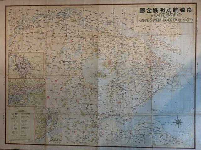
Jing Hu Hang Yong mingxi quantu. A Comprehensive Map: Nanking, Shanghai, Hangchow and Ningpo
SHANGHAI GEOGRAPHICAL SOCIETY (Shanghai Yudi Xueshe) · Shanghai · Shanghai Geographical Society (Shanghai Yudi Xueshe) · 1937
A large bilingual Chinese and English colour-lithographed map of the Yangtze delta and the Nanking, Shanghai, Hangchow and Ningpo region, published in Shanghai in 1937, the year the Sino-Japanese War broke out in this very area; with three inset city plans. Very rare: the only other copy traced is in the Library of Congress
FM-0164
€ 1.000
Key Properties
Edition: Shanghai Geographical Society, 1937
Language: Bilingual, Chinese and English
Format: Colour lithograph on wove paper, folded as issued
Sheet: 79 x 100 cm
Insets: Three inset city plans (Nanking, Shanghai, Hangchow) in the left margin, with a legend of conventional signs
Rarity: The only other copy traced is in the Library of Congress, Washington
Collation & Technical Description
A single large sheet, printed in colour lithography, the title in Chinese characters (Jing Hu Hang Yong mingxi quantu, that is 'detailed complete map of Nanking, Shanghai, Hangchow and Ningpo') and in English (A COMPREHENSIVE MAP: NANKING, SHANGHAI, HANGCHOW AND NINGPO) in a panel at the upper right. The map covers the lower Yangtze region from Nanking in the north-west, down the river to Shanghai and the mouth of the Yangtze, and south across Hangchow Bay to Hangchow, Shaohsing and Ningpo, with the Chusan archipelago at the right edge. The provinces of KIANGSU and CHEKIANG are lettered across the map. Railways, roads, waterways, canals and the many towns and villages of the delta are shown, the place-names in Chinese with the principal names also in romanised form; the low-lying land and lakes tinted, the sea in blue. Along the left edge three inset plans of the cities of Nanking, Shanghai and Hangchow, below them the legend of conventional signs; a compass rose in the lower right. Imprint of the Shanghai Geographical Society and date in the margins.
Condition
A complete example with fresh colours, folded as issued, with light wear along the folds and the paper lightly toned. Detailed condition report available on request.
References & Bibliography
Library of Congress, Geography and Map Division, holdings of maps published by the Shanghai Yudi Xueshe (Shanghai Geographical Society), the only other copy of this map traced.
Description
A large and very rare bilingual map of the Yangtze delta, the most densely populated and economically important region of Republican China, published in Shanghai by the Shanghai Geographical Society (Shanghai Yudi Xueshe) in 1937. The map takes as its subject the four cities named in its title, Nanking (Nanjing), the national capital, Shanghai, the great commercial port, and Hangchow (Hangzhou) and Ningpo (Ningbo) on the southern shore of Hangchow Bay, together with the whole of the low country between them: the Yangtze estuary, the lake district of Kiangsu (Jiangsu), the Grand Canal and the northern part of Chekiang (Zhejiang).
The Shanghai Geographical Society was one of the Chinese commercial map publishers active in Shanghai, then the centre of the Chinese printing industry, issuing colour-lithographed maps for a public that was increasingly hungry for modern cartography. The present map is unusual in being fully bilingual, the title and principal names given in English as well as Chinese, which suggests it was aimed also at the large foreign community of Shanghai and at the foreign business houses, missions and consulates that operated throughout the region.
The map shows the region in remarkable detail: the railway lines from Shanghai to Nanking and from Shanghai to Hangchow and Ningpo, the new motor roads, the intricate network of creeks and canals of the delta, and hundreds of towns and villages. The three inset plans give the street layout of Nanking within its walls, of Shanghai with its International Settlement and French Concession, and of Hangchow on the West Lake.
The date gives the map a particular historical charge. In 1937, the year of publication, the Sino-Japanese War broke out, and the region depicted became its first great battlefield: the Battle of Shanghai from August to November 1937, the Japanese landings on Hangchow Bay, the advance across exactly this country, and the fall of Nanking in December. Maps of this area published on the eve of the conflict were used, and used up, on both sides, and few survived. The card that accompanied this example when it came into stock records that only one other copy could be traced, in the Library of Congress in Washington.
Historical Significance
The Yangtze delta between Nanking, Shanghai, Hangchow and Ningpo was the economic and political heart of Republican China, and in 1937 it became the principal theatre of the first months of the Sino-Japanese War. A large, detailed and bilingual map of the region published in that very year is a document of the last moment of the pre-war order, and a rare survival of Chinese commercial cartography of the period, which was produced in quantity but seldom preserved.
Provenance
Available on request.