Antique Maps
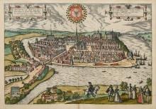
CHILONIUM, VULGO KYELL
Georg Braun and Frans Hogenberg · Cologne · Braun & Hogenberg · First published 1588
Braun & Hogenberg, city view of Kiel
FM-0018
€ 800
Key Properties
Edition: Civitates Orbis Terrarum (vol. IV)
Language: Latin
Collation & Technical Description
Hand-coloured copper engraving. Plate approx. 32.8 × 48.5 cm; frame approx. 74.7 × 82.7 cm. View of Kiel across the Kieler Förde with the Nikolaikirche, the harbour with sailing ships, and richly dressed foreground figures.
Condition
The sheet appears above-average attractive, with powerful colours, wide margins and a clear impression. The centre fold is normal; the closed frame prevents checking of mounting and verso.
References & Bibliography
Georg Braun & Frans Hogenberg, Chilonium (Kiel), from Civitates Orbis Terrarum, Cologne; the view first published 1588 (vol. IV).
Cf. the Taschen facsimile edition of Braun & Hogenberg.
Description
This city view shows Kiel from across the Kieler Förde. The Nikolaikirche stands at the centre, the harbour with sailing ships lies to the right, and richly dressed figures and a horseman appear in the foreground.
The sheet comes from the Civitates Orbis Terrarum of Braun and Hogenberg. The original publication was in volume IV in 1588; without a verso image the precise edition remains uncertain.
The maritime subject, the recognisable harbour city and the strong colours make this an appealing sixteenth-century city view.
Notable features: Kiel as a historic harbour city; Rich figurative foreground, ships and the city arms; Fitting provenance from a Hamburg shipping collection.
Historical Significance
From the Civitates Orbis Terrarum, the first systematic atlas of city views; a strong maritime view of the harbour city of Kiel.
Provenance
Hamburg shipping collection.