Antique Maps
Amsterdam (Plan of Amsterdam)
MERIAN, Caspar (and Matthäus Merian the Elder) with Martin Zeiller · Frankfurt am Main · Caspar Merian · 1659 (plate first published 1654)
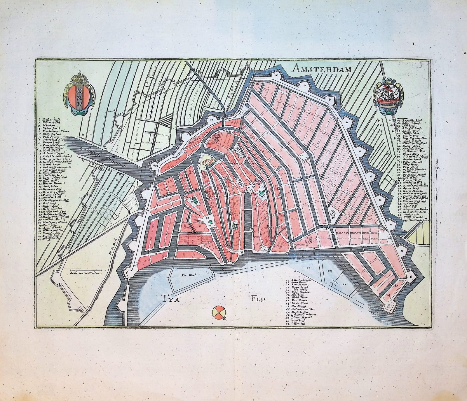
Merian's plan of Amsterdam from the Topographia Germaniae Inferioris, Frankfurt 1659, in old hand colour: the city inside the ramparts of 1613, with the three great canals, the Jordaan and the eastern islands, and a German key to one hundred numbered places.
FM-0202
€ 850
Key Properties
Edition: Martin Zeiller and Matthäus/Caspar Merian, Topographia Germaniae Inferioris, Frankfurt am Main, Caspar Merian; first published 1654, this impression from the 1659 issue.
Technique: copper engraving, hand-coloured in an old palette (blocks in red, canals and the IJ in blue, meadows and fields in green, arms in full colour).
Title: AMSTERDAM, in capitals at the top; the arms of Amsterdam (crowned shield with the three St Andrew's crosses) top left and the emblem of the city with the cog ship top right.
Key: a hundred numbered places in German (1 Ryssen-hooft to 100 Grimmensesluess), set in columns at left, right and in the water of the IJ; the scale 'Scala von 100 Ruthen' lower left; compass rose in the IJ.
Geography: 'Tya Flu.' (the IJ), 'Amstela Fluvius', 'De Wael' and 'De Ka Dijk' named; the polder land around the town shown with its ditches and dykes.
Dimensions: platemark approximately 26 x 32 cm; sheet 33 x 38 cm.
Verso blank.
Collation & Technical Description
One engraved sheet, verso blank, with the vertical centre fold as issued in the folio volume. Platemark approximately 26 x 32 cm, the sheet 33 x 38 cm, with wide margins on all sides. The plan is a bird's-eye ground plan: the blocks of houses in solid tint, the canals, ramparts and bastions in outline, the churches and public buildings shown in elevation.
Condition
Very good. Old hand colour, fresh and unfaded. Centre fold as issued, flat and clean, without splitting. Paper strong and evenly toned, a few small fox marks in the margins, the image itself clean. Wide margins.
References & Bibliography
Wüthrich, Das druckgraphische Werk von Matthaeus Merian d. Ae., vol. IV (Die grossen Buchpublikationen: Topographia), s.v. Topographia Germaniae Inferioris. Fauser, Repertorium älterer Topographie, s.v. Amsterdam (Merian). Zeiller/Merian, Topographia Germaniae Inferioris, Frankfurt 1654 and 1659.
Description
The plan of Amsterdam from the Topographia Germaniae Inferioris, the volume of the Merian Topographia devoted to the Seventeen Provinces of the Netherlands. The Topographia, begun by Matthäus Merian the Elder in 1642 and continued after his death in 1650 by his sons Matthäus the Younger and Caspar, is the great German picture-book of European towns of the seventeenth century, and the Netherlands volume, with text by Martin Zeiller, appeared in Frankfurt in 1654 under the imprint of Caspar Merian. The present sheet comes from the second issue of 1659.
The plan shows Amsterdam as it was between the third expansion of 1613 and the fourth of 1663: inside the ramparts with their pointed bastions lie the old town on the Amstel with the Dam, the Oude Kerk and the Nieuwe Kerk, the western ring of the Herengracht, Keizersgracht and Prinsengracht as far as the Leidsegracht, the Jordaan with the Westerkerk and the Noorderkerk, the Lastage and the eastern islands of Uilenburg, Marken and Rapenburg. The Exchange ('Die Beursse'), the weigh-houses, the doelens of the civic guard, the Dutch and West India houses, the almshouses, the gates and the sluices are all located by number in a key of one hundred entries, written in the German of the Frankfurt engraver: 'Nowe Kirch', 'Der Damm', 'Kloveniers Doelen'. Outside the walls the polder land is drawn with its ditches, and the IJ, called 'Tya Flu.' after the Dutch 't IJ, fills the foreground with the Waal and the harbour.
Merian's plan reduces the great Dutch wall maps of the city in the tradition of Balthasar Florisz van Berckenrode to a single folio sheet, and it is the form in which the plan of the Golden Age city was most widely seen in Germany. This impression is in old hand colour: the blocks of houses washed in red, the water in blue, the fields in green, and the two coats of arms fully coloured.
Historical Significance
The Merian Topographia was the most ambitious topographical publication of the German seventeenth century, and its Netherlands volume of 1654 gave the German-speaking public its standard picture of the Dutch Republic at the height of its power. The Amsterdam plan records the city in the decade before the fourth expansion, when the canal ring still ended at the Leidsegracht and the ramparts of 1613 enclosed a city of some 150,000 inhabitants that had become the warehouse and exchange of Europe. With its hundred-item key naming the East and West India houses, the Exchange, the Bank on the Dam and the many churches, almshouses and doelens, the plan is a portrait of the institutions that made that prosperity possible.
Provenance
Frederik Muller Rare Books, Amsterdam (stock of the firm).