Antique Maps
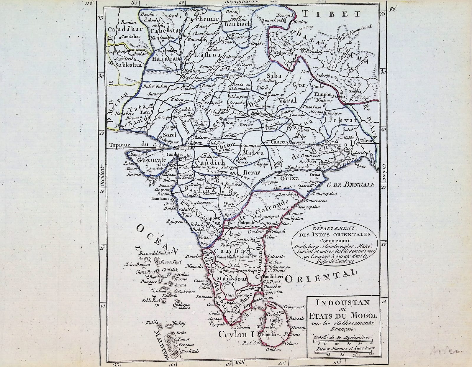
Indoustan ou Etats du Mogol avec les établissements Français (India)
ROBERT DE VAUGONDY, Gilles and Didier; DELAMARCHE, Charles-François · Paris · Charles-François Delamarche (successor to Robert de Vaugondy) · c. 1806 (plate first published 1749, revised for the metric edition)
Small map of India and Ceylon from Delamarche's revised issue of the Vaugondy Atlas portatif, Paris c. 1806, with the French trading posts named in a cartouche, the scale in myriamètres, and outline colour by hand.
FM-0205
€ 175
Key Properties
Edition: Robert de Vaugondy, Nouvel atlas portatif, in the revised issue published by Charles-François Delamarche, Paris, after the introduction of the metric system; the plate first published in 1749 (Pedley 388), here in its later state with the title 'Indoustan ou Etats du Mogol avec les établissements Français', without the 1749 date and the Vaugondy imprint.
Dating evidence: the scale reads 'Echelle de 50 Myriamètres' above 'Lieues Marines et d'une heure'; the myriamètre was created with the metric system of 1795, so this state cannot be earlier than the late 1790s; the atlas was reissued in updated form in 1806, which fits the setting of this sheet.
Content: the subcontinent from Kandahar and Kashmir to Cape Comorin and Ceylon, with the Maldives and the Laccadives; the provinces of the Mughal empire (Lahor, Delly ou Gehannabad, Agra, Bengale, Guzurate, Golconde, Malabar, Coromandel and others); the oval cartouche 'Département des Indes Orientales comprenant Pondichery, Chandernagor, Mahé, Karical et autres établissements avec un Comptoir à Surate dans le Golfe de Cambaye'.
Colour: political boundaries outlined by hand in red, green, blue and yellow.
Dimensions: neat line 153 x 198 mm, outer border 161 x 206 mm.
Page number 68 in the upper right corner; pencil note 'Asien' in the lower margin.
Verso blank.
Collation & Technical Description
One engraved leaf, verso blank, the map with graduated border, the page number 68 engraved in the upper right corner outside the border. Neat line 153 x 198 mm, outer border 161 x 206 mm.
Condition
Good. Paper evenly age-toned, a few small spots, light traces of the colour on the verso. Outline colour by hand, applied in a slightly uneven wash. A pencil note 'Asien' in the lower right margin. Margins to be measured; no tears or repairs visible.
References & Bibliography
Pedley, Bel et Utile: the Work of the Robert de Vaugondy Family of Mapmakers (1992), 388 (the plate of 1749) and the Delamarche issues of the Nouvel atlas portatif. Phillips, A List of Geographical Atlases in the Library of Congress, 608 (the 1749 atlas). Shirley, Maps in the Atlases of the British Library, T.ROBV-2a.
Description
A small map of the Indian subcontinent from the Nouvel atlas portatif of the Robert de Vaugondy family, in the revised state published by their successor Charles-François Delamarche. The plate was first engraved in 1749 for Gilles and Didier Robert de Vaugondy's pocket atlas, then titled Indoustan ou Etats du Mogol and dated in the title panel. Delamarche, who acquired the Vaugondy stock of plates in 1786, kept the atlas in print for decades and brought the plates up to date. On the present state the Vaugondy imprint and the date have been removed, the title extended with 'avec les établissements Français', and the scale converted to the new unit of the Republic, the myriamètre, above the old scale of marine leagues. The oval cartouche at the right lists the French possessions in India, Pondichéry, Chandernagor, Mahé, Karikal and the factory at Surat, the establishments that France recovered at the peace settlements and that the atlas was meant to teach.
The map covers the subcontinent from Kandahar and Kashmir in the north to Cape Comorin and Ceylon, with the Maldives and the Laccadives in the Indian Ocean. It keeps the Mughal provinces of the 1749 plate, Lahor, Delhi ('Delly ou Gehannabad'), Agra, Bengal, Gujarat, Golconda, and the coastal regions of Malabar and Coromandel, with the European settlements marked: Goa, Bombay, Surat, Madras, Tranquebar, Negapatam and the French posts. The boundaries are outlined by hand in red, green, blue and yellow.
Historical Significance
The Vaugondy pocket atlas was one of the most widely used school atlases in France for half a century, and the Delamarche reissues carried it from the ancien régime into the Napoleonic era. This state of the India map, with its metric scale and its cartouche of the French comptoirs, records the moment when France, having lost the contest for India to the British East India Company, still defined its remaining foothold on the subcontinent as a 'Département des Indes Orientales'.
Provenance
Frederik Muller Rare Books, Amsterdam (stock of the firm).