Antique Views
Duynkercke (Dunkirk)
BRAUN, Georg and HOGENBERG, Frans · Cologne · Georg Braun and Frans Hogenberg (Civitates Orbis Terrarum, Book II) · 1575-1612 (plate first published 1575)
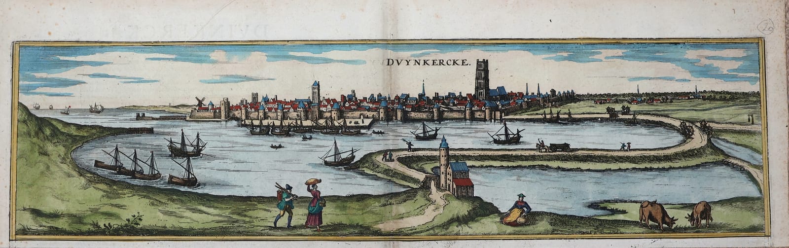
Bird's-eye view of Dunkirk from Braun and Hogenberg's Civitates Orbis Terrarum, Cologne, Book II, in old hand colour: the fortified harbour town on the Flemish coast with its great church tower, the roadstead full of ships and the road along the dyke.
FM-0209
€ 225
Key Properties
Edition: Georg Braun and Frans Hogenberg, Civitates Orbis Terrarum, Book II, first published at Cologne in 1575 and reissued to 1612; the present impression from one of the Latin editions, with the letterpress text of the atlas on the verso.
View: 'Duynkercke', the view of Dunkirk only, the upper of the three views of Dunkirk, Gravelines and Bourbourg that share one sheet in the atlas (Van der Krogt IV, 1168), cut from the sheet with margins around the view; the town seen from the sea side across the harbour, with the tower of St Eloi, the town walls and gates, the jetties and the dyke road with a windmill and carts; sailing ships and boats in the roadstead; in the foreground peasants, a man with a spade, a woman carrying a basket, a girl with a jug and grazing cattle.
Colour: old hand colour, the roofs in red, the fields in green, the water and sky in blue.
Dimensions: the view approximately 12 x 37 cm, the leaf trimmed to the Dunkirk view with margins on all sides.
Pencil number 20 in the upper right margin.
Collation & Technical Description
The engraved view of Dunkirk alone, separated from the sheet that also carried Gravelines and Bourbourg, with the letterpress text of the atlas on the verso. View approximately 12 x 37 cm, with margins on all sides.
Condition
Very good. Old hand colour, bright and fresh. Paper clean, a few small fox spots in the margins, the text on the verso faintly showing through in the upper margin.
References & Bibliography
Van der Krogt, Koeman's Atlantes Neerlandici, IV, 1168 (the sheet with Dunkirk, Gravelines and Bourbourg). Fauser, Repertorium älterer Topographie, s.v. Dünkirchen. Taschen, Braun and Hogenberg, Cities of the World, p. 162.
Description
The view of Dunkirk from the second book of the Civitates Orbis Terrarum, the great town book of Georg Braun and Frans Hogenberg that appeared in six volumes at Cologne between 1572 and 1617 and gave Europe its first systematic collection of city views. Dunkirk shares its sheet in the atlas with the neighbouring Flemish ports of Gravelines and Bourbourg, the three views set one above the other; the present view is the upper one, the largest of the three, here offered on its own, separated from the two smaller views.
The town is seen from the sea across the harbour basin, an oblong of water enclosed by the dyke road that runs out to the jetties, with the wide roadstead beyond. Behind the walls with their round towers and gates rises the massive tower of St Eloi, the belfry that still dominates the town, with the church beside it and the roofs of the town spread out along the shore; windmills stand on the walls and on the dunes. Fishing boats and sea-going ships lie at anchor and under sail, carts and travellers pass along the dyke, and in the foreground Hogenberg placed the figures that give the Civitates views their charm: a countryman with a spade, a woman with a basket on her head, a girl seated with a jug, and cows at pasture. Dunkirk in the 1570s was a Habsburg port and a base for privateers; it would become, under Spain and then France, the most fought-over harbour of the Channel coast.
This impression is in old hand colour, with the roofs in red, the fields in green and the water and sky in blue.
Historical Significance
The Civitates Orbis Terrarum is the companion to Ortelius' Theatrum and the first atlas of the cities of the world. Its views of the Flemish coast, drawn in the years of the Dutch Revolt, record the harbour towns as they were before the sieges and the fortifications of the seventeenth century. Dunkirk, a fishing port and privateers' base under Spain, taken by the French in 1646 and 1662, was rebuilt by Vauban as a great naval harbour, so that the Braun and Hogenberg view is the standard picture of the medieval town before that transformation.
Provenance
Frederik Muller Rare Books, Amsterdam (stock of the firm).