Antique Maps
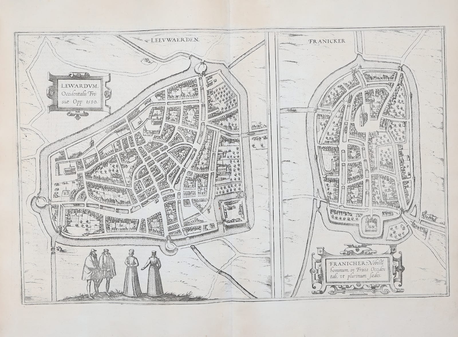
Lewardum, Occidentalis Frisiae Opp. 1580 / Franicher, Nobilium hominum in Frisia Occidentali ut plurimum saedes (Leeuwarden and Franeker)
BRAUN, Georg and HOGENBERG, Frans · Cologne · Georg Braun and Frans Hogenberg · 1581 or later (Latin text edition of Civitates Orbis Terrarum, Book III)
The two Frisian towns of Leeuwarden and Franeker in bird's-eye plan from the third book of Braun and Hogenberg's Civitates Orbis Terrarum, Leeuwarden dated 1580 in the cartouche and shown with its new ramparts and the castle of the Stadhouder, with four Frisian figures in the foreground; a fine uncoloured impression with Latin text on the verso.
FM-0213
€ 750
Key Properties
Edition: from a Latin text edition of Book III of the Civitates Orbis Terrarum, first published in Cologne in 1581; Latin text on the verso.
Plans: two bird's-eye plans on one sheet, divided by a rule: Leeuwarden at the left, with the title cartouche 'Lewardum, Occidentalis Frisiae Opp. 1580', the walls and bastions, the canals, the Oldehove and the other churches, the blockhouse of the Stadhouder at the lower right and four figures in Frisian dress in the foreground; Franeker at the right, with the cartouche 'Franicher, Nobilium hominum in Frisia Occidentali ut plurimum saedes', the ramparts and moat, the church and the Sjaerdemaslot at the foot of the town.
Source: the Leeuwarden plan after the survey of Jacob van Deventer and the drawing sent to Braun from Friesland; Franeker likewise after Van Deventer.
Colour: uncoloured, as issued.
Dimensions: engraved surface approximately 33 x 48 cm.
Verso: Latin letterpress text.
Collation & Technical Description
One engraved sheet with the vertical centre fold as issued, two plans on one plate, Latin text on the verso. Engraved surface approximately 33 x 48 cm, with margins.
Condition
Very good. A clear, strong impression on clean paper. Centre fold as issued. Faint even age-toning; margins a little dust-soiled at the extremities. Uncoloured, as issued.
References & Bibliography
Van der Krogt, Koeman's Atlantes Neerlandici IV, Braun and Hogenberg, Civitates Orbis Terrarum, Book III. Fockema Andreae and Van 't Hoff, Geschiedenis der kartografie van Nederland, for Van Deventer's town plans. Taschen, Braun and Hogenberg, Cities of the World, for the plates.
Description
The two principal towns of Friesland as they appeared at the moment the province threw in its lot with the Revolt. Leeuwarden, the seat of the provincial court and from 1584 of the Frisian Stadhouders of the house of Nassau, is shown from above with its canals, its three parishes and, at the lower right, the blockhouse that the Habsburg governor had built in 1499 to hold the town in check and that the citizens would demolish in 1580, the very year given in the cartouche. Franeker, the university town from 1585, is shown with its moat and ramparts and, outside the walls at the foot, the Sjaerdemaslot, the stronghold of the family that gave the town its title of a seat of noblemen, 'nobilium hominum saedes'.
Both plans derive from the surveys that Jacob van Deventer made of the towns of the Netherlands for Philip II in the 1560s, and they were engraved by Frans Hogenberg for the third book of the Civitates Orbis Terrarum, the great town atlas that Georg Braun edited in Cologne from 1572 as a companion to Ortelius' Theatrum. The third book appeared in 1581 and was reprinted in Latin, German and French into the seventeenth century; this impression, with Latin text on the verso, comes from one of the Latin editions. The four figures in the foreground of the Leeuwarden plan, two burghers in cloaks and two women in the long dress and hood of the province, are the costume figures that Braun added to every plate, as he explained, to keep the atlas out of the hands of the Turks, who would not tolerate images of people.
Historical Significance
These are the earliest printed plans of Leeuwarden and Franeker and, with the Van Deventer manuscripts, the basis of everything we know of the appearance of the two towns in the sixteenth century. Leeuwarden is shown at the turning point of its history, dated 1580 by the engraver, when the town went over to the Union of Utrecht and demolished the Habsburg blockhouse, and Franeker as it was on the eve of the founding of its university in 1585, the second of the Republic after Leiden.