Antique Maps
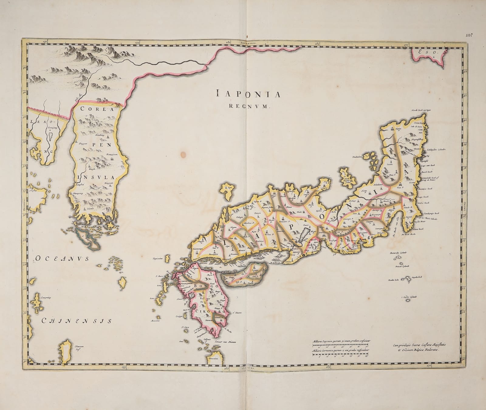
Iaponia Regnum (The Kingdom of Japan, with Korea)
BLAEU, Joan (after Martino Martini) · Amsterdam · Joan Blaeu · 1655-1662 (plate first published 1655)
Blaeu's map of Japan and Korea from the Novus Atlas Sinensis of the Jesuit Martino Martini, in old colour: the Japanese provinces outlined in pink, green and yellow, Korea as a peninsula, Yezo (Hokkaido) in the upper corner, with the Dutch names given to the eastern capes on the voyage of Vries in 1643; with the privilege of the Emperor and the States General.
FM-0214
€ 2.700
Key Properties
Edition: Joan Blaeu's map of Japan, first published in 1655 as the last map of Martino Martini's Novus Atlas Sinensis, the sixth part of Blaeu's Theatrum Orbis Terrarum, and continued in the Atlas Maior from 1662; from a text edition of one of these atlases, with the manuscript number 115 in the upper corner of an early owner.
Map: Japan with its provinces, Corea Pen-Insula (Korea shown correctly as a peninsula), the coast of China with Leao-Tung and the Yalu, Eso (Yezo, Hokkaido) at the upper right, Tanaxima and the Straet van Diemen to the south; the eastern coasts carrying the Dutch names of the voyage of Maarten Gerritsz. Vries of 1643 (Noorde hoeck van Iapan, Cabo de Kennis, Schildpadts Eylanden, Bommelties hoeck, Iapanse Rivier); scales of Japanese and German miles at the lower right, with the privilege 'Cum privilegio Sacrae Caesareae Majestatis et Ordinum Belgicae Foederatae'.
Source: the Jesuit maps of Martino Martini, based on Chinese and Japanese materials, combined with the Dutch surveys of the east coast of Honshu and Yezo made from Batavia.
Colour: old hand colour, the provinces in outline, the borders in yellow, Yezo in red.
Dimensions: engraved surface approximately 41 x 50 cm; sheet approximately 53 x 63 cm.
Verso: letterpress text.
Collation & Technical Description
One engraved sheet with the vertical centre fold as issued, letterpress text on the verso. Engraved surface approximately 41 x 50 cm, the sheet approximately 53 x 63 cm, with wide margins.
Condition
Good. Old hand colour, fresh. Centre fold as issued. Paper lightly age-toned with scattered small foxing spots, a faint stain in the sea above the title and a few marks in the margins; the impression strong and even. A full sheet with wide margins.
References & Bibliography
Van der Krogt, Koeman's Atlantes Neerlandici II, Blaeu, Atlas Maior, the map of Japan in the Novus Atlas Sinensis. Hubbard, Japoniae Insulae: The Mapping of Japan (2012). Walter, Japan: A Cartographic Vision (1994). Cf. Schilder, Monumenta Cartographica Neerlandica, for the Vries voyage of 1643.
Description
Joan Blaeu's map of Japan, the most authoritative European map of the country in the second half of the seventeenth century and the first in a general atlas to show Korea as a peninsula rather than an island. It closes the Novus Atlas Sinensis, the atlas of China that the Jesuit missionary Martino Martini brought back from the East and that Blaeu published in Amsterdam in 1655 as the sixth part of his Theatrum Orbis Terrarum. Martini's maps were based on Chinese sources and on the reports of the Jesuits in Japan, and for this sheet Blaeu combined them with what the Dutch East India Company had learned on the spot: the east coast of Honshu and the southern coast of Yezo carry the Dutch names given by Maarten Gerritsz. Vries, who sailed from Batavia in 1643 in search of the gold and silver islands and charted the coasts north of Edo, the Kuriles and the south of Sakhalin. Yezo, still a mystery to Europeans, appears as an unexplored coast in the upper corner.
The map shows the sixty-six provinces of Japan outlined in colour, with their castles and towns, Meaco (Kyoto) with the lake of Biwa, Osacca, Sacai and Nangasaqui, the port where the Dutch had their factory on Deshima, the island of Tanaxima where the Portuguese first landed in 1543, the Straet van Diemen named after the governor-general, and across the sea the peninsula of Korea with the frontier of China on the Yalu. The map was printed for the Latin, French, Dutch, German and Spanish editions of the atlas and, from 1662, for the Atlas Maior, and remained the standard picture of Japan until the maps of Kaempfer and Reland in the early eighteenth century. This example, in old colour and with wide margins, carries the manuscript number 115 of an early owner.
Historical Significance
For a century after the closing of Japan in 1639 the Dutch were the only Europeans admitted to the country, and Blaeu's map, made in the city of the East India Company from the Jesuit and Company materials together, was Europe's window on the Japanese archipelago. It fixed the outline of Japan and the peninsular form of Korea for the rest of the seventeenth century and was copied by every atlas maker in Europe. As a Blaeu map in old colour from the Atlas Maior, the summit of Dutch atlas production, it is also one of the classic decorative maps of the Far East.