Atlases
Atlas historique, généalogique, chronologique et géographique de A. Le Sage (comte de Las Cases), avec des augmentations par J. Marchal, de Bruxelles
LE SAGE, A. (Emmanuel-Augustin-Dieudonné, comte de LAS CASES); MARCHAL, J. · Brussels · P. J. de Mat, imprimeur-libraire éditeur, Grande Place · 1827 (the tables dated 1823-1827)
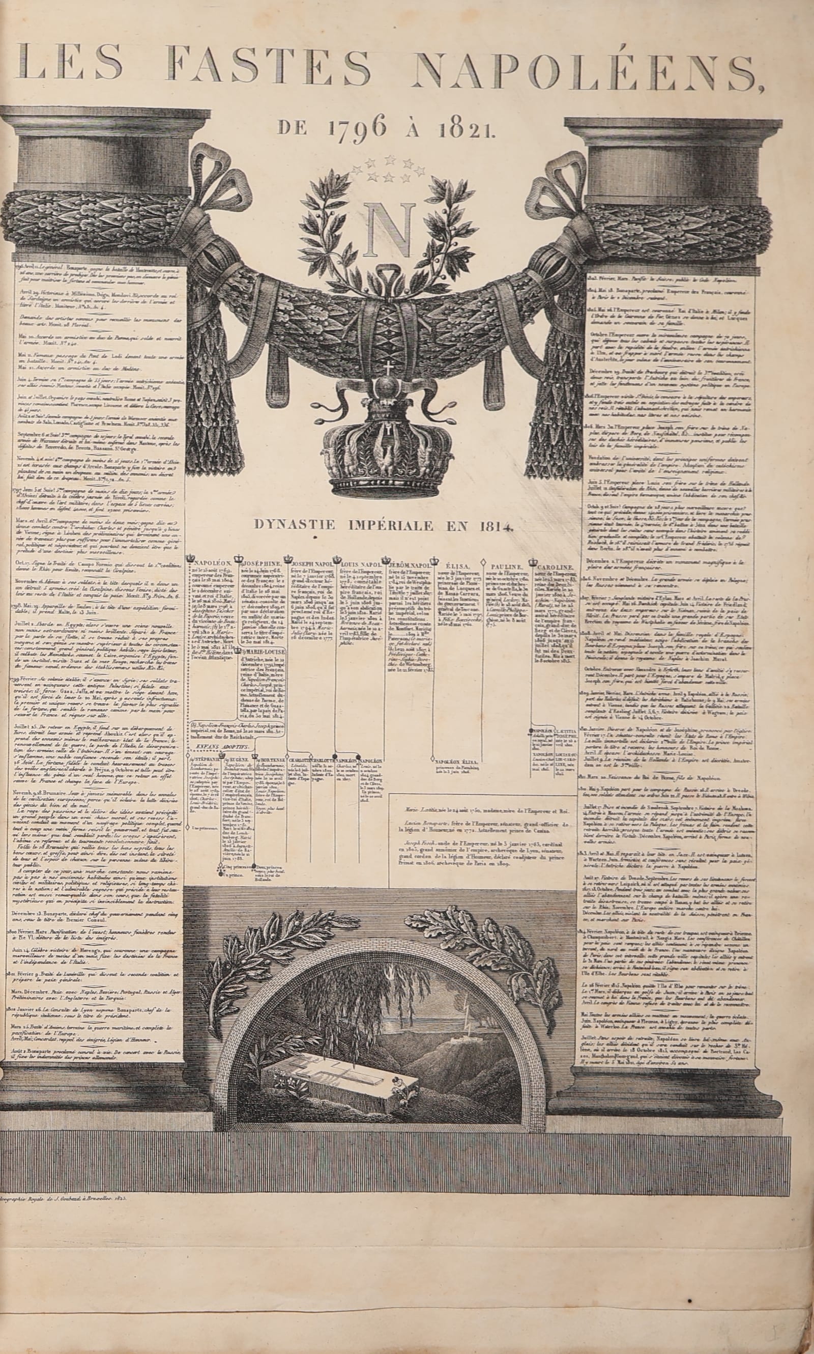
The Brussels edition of the famous Le Sage atlas of Las Cases, Napoleon's companion on St Helena, with the tables added for the Netherlands by J. Marchal and the great engraved memorial sheet Les Fastes Napoléens; 36 large engraved tables and maps in contemporary outline colour, in the original printed boards.
FM-0215
€ 750
Key Properties
Edition: the Brussels edition printed and published by P. J. de Mat, Grande Place, 1827, with the tables dated 1823 to 1827, 'avec des augmentations par J. Marchal, de Bruxelles, et de nombreuses améliorations par une société de savans et de gens de lettres'; the tables engraved and printed at the Calcographie royale of J. Goubaud in Brussels.
Contents: half-title, title, and 36 double-page tables (the number given by the vendor and counted in the volume) combining engraved maps, genealogical trees and chronological tables with letterpress text in columns, among them Les Fastes Napoléens de 1796 à 1821 with the Imperial dynasty in 1814 and the tomb at St Helena; Le Monde connu des Anciens; La Grèce ancienne historique et fabuleuse; L'Empire Romain; the Tableau généalogique of England with the Iles Britanniques; Italy under Napoleon with his campaigns; Spain and Portugal; the Tableau géographique et historique des Pays-Bas with the Carte comparative de l'état ancien et actuel des Pays-Bas (supplementary table XXI, dated 1826, special to the Brussels edition) preceded by the Discours préliminaire de l'édition de Bruxelles on the history of the Netherlands; the Mappe-monde historique with the navigators; Africa with the discoveries of the Europeans; and America 'historique, physique et politique en 1827' with the new states.
Format: large folio, approximately 62 x 45 cm, the tables double-page.
Colour: the maps in contemporary outline and wash colour.
Binding: the original publisher's binding of half red cloth with small corners, the boards covered with the printed title-wrapper within an ornamental border, the front board with the vignette and the imprint of De Mat, 1827.
Language: French.
Collation & Technical Description
Large folio. Half-title, title (with a woodcut vignette), the Discours préliminaire de l'édition de Bruxelles (Histoire des Pays-Bas), and 36 engraved double-page tables, each mounted on a guard, the maps in contemporary colour; the tables numbered in the Brussels and Paris sequences at the foot and dated 1823 to 1827.
Condition
Good. In the original publisher's half cloth with printed boards, the boards rubbed and soiled with small defects at the edges, the spine sound with the printed label. Internally a good copy: the tables clean and strong, with foxing and some damp staining, chiefly in the margins and heavier on a few leaves; the half-title with an offset of the title and some marks; the maps with their colour fresh. An unsophisticated copy in its first binding.
References & Bibliography
Cf. Phillips, A List of Geographical Atlases in the Library of Congress, 3327 and 3331 (Paris editions of the Le Sage atlas); Tooley's Dictionary of Mapmakers, Las Cases. For the Brussels edition of De Mat: Bibliographie nationale de Belgique.
Description
The Le Sage atlas is one of the most original works of historical cartography of the early nineteenth century. Its author, Emmanuel de Las Cases (1766-1842), a naval officer who had emigrated at the Revolution and lived by his pen in London, published it there in 1801 under the pseudonym A. Le Sage as the Atlas historique, généalogique, chronologique et géographique; it made his fortune and, after his return to France, brought him to the notice of Napoleon, whom he followed into exile on St Helena and whose Mémorial de Sainte-Hélène he wrote. The atlas takes history as its subject and geography as one of its instruments: each large table combines a map, a genealogical tree, a chronological table and columns of letterpress text so that the reader may take in at a glance the succession of dynasties, the shifting frontiers and the course of events of one country or one period. It went through many editions in Paris and was imitated all over Europe.
This is the Brussels edition, printed and published by P. J. de Mat, printer to the court, on the Grand-Place in 1827, from tables engraved at the Calcographie royale of Goubaud between 1823 and 1827. It was revised for the new Kingdom of the Netherlands by the Brussels writer J. Marchal 'and a society of scholars and men of letters', and has what the Paris editions lack: a Discours préliminaire on the history of the Low Countries, a supplementary table with a comparative map of the Netherlands old and new, with the genealogy of the house of Orange-Nassau and the constitution of the kingdom, and the striking sheet Les Fastes Napoléens, an engraved monument with columns, garlands and the imperial crown framing a chronology of the years 1796 to 1821, the genealogy of the imperial family in 1814 and, at the foot, the tomb under the willows at St Helena, published by Goubaud in 1823. The maps range from the world known to the ancients and ancient Greece and Rome to the Netherlands, England, Italy under Napoleon, Spain, Africa with the European discoveries, a historical map of the two hemispheres with the routes of the navigators, and America 'in 1827' with the new republics.
The copy is in the publisher's binding of half red cloth with the printed boards, the front board carrying the printed title within its border of rosettes, as it was sold in Brussels in 1827; the maps are in contemporary colour. With the usual foxing and some damp marks of a large volume that has been used, but complete and unrestored.
Historical Significance
Las Cases's atlas taught two generations of Europeans to see history and geography together, and its layered tables are among the ancestors of the modern historical atlas and of the graphic presentation of information. The Brussels edition of 1827 belongs to the short life of the United Kingdom of the Netherlands (1815-1830) and is a document of the Belgian book trade of those years, when De Mat and the other Brussels houses reprinted the successes of Paris for the Dutch and Belgian market and adapted them with their own additions. The Fastes Napoléens, published two years after the Emperor's death, is a piece of the Napoleonic cult in the Netherlands of King William I.