Antique Maps
Atlas Curieux oder Neuer und Compendieuser Atlas, a volume with 59 engraved maps, charts and tables
Gabriel Bodenehr · Augsburg · Gabriel Bodenehr · c. 1704
Bodenehr's Augsburg pocket atlas of the War of the Spanish Succession: engraved title and 59 maps, charts and tables in contemporary outline colour, with Vigo 1702 and the battle of Málaga 1704.
FM-0055
€ 3.000
All prices include VAT. Import duties outside the EU are not included.
Free insured shipping. The price shown is the price you pay.
Key Properties
Maker: Gabriel Bodenehr
Place: Augsburg
Date: c. 1704
Contents: engraved title, printed contents leaf and 59 engraved maps, charts and tables, contemporary outline colour
Format: Small format
Binding: contemporary limp leather wallet binding with fore-edge flap
Condition
Incomplete: 59 of the maps and tables listed in the printed contents leaf (101 numbers, the first three of two maps each). The contemporary wallet binding in good, attractive condition. Many leaves are loose from the binding but held in place within it. Maps in contemporary outline colour.
Description
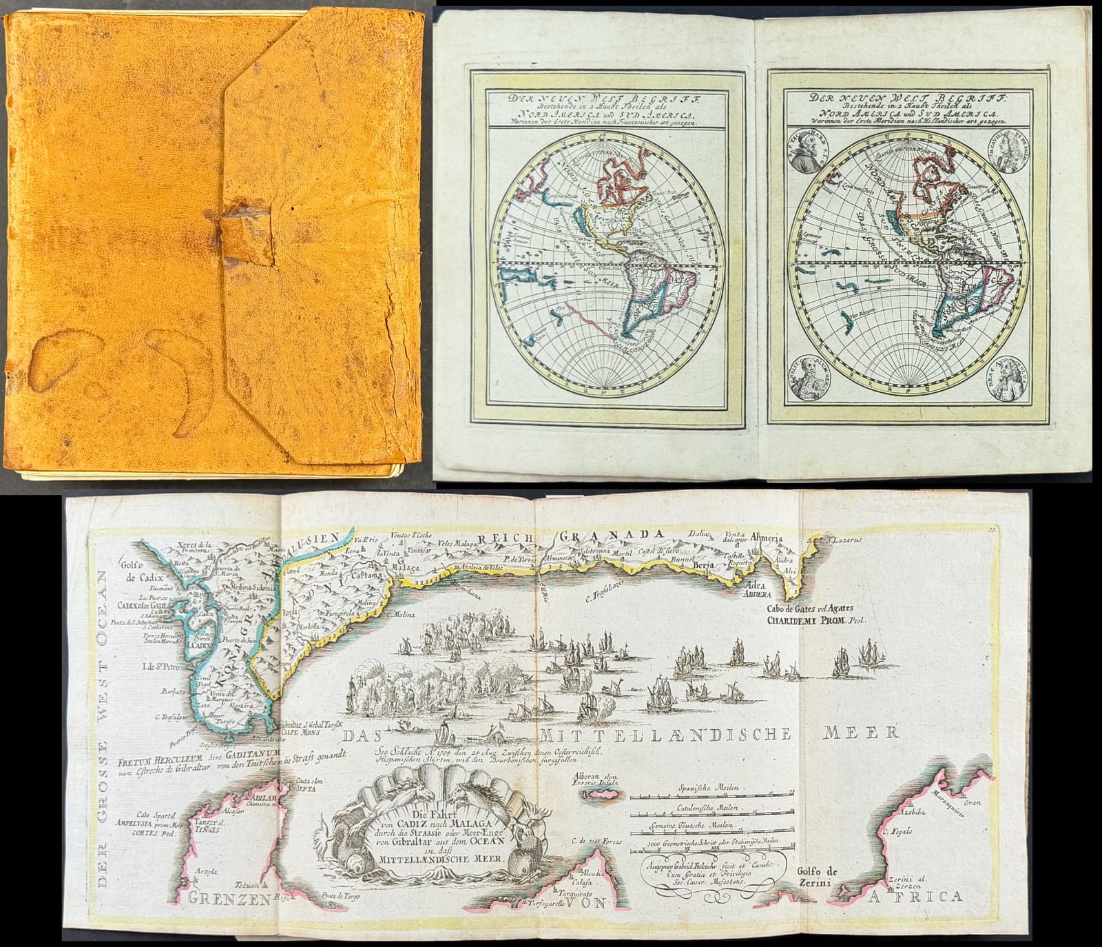
A volume of Gabriel Bodenehr's Atlas Curieux oder Neuer und Compendieuser Atlas, the pocket atlas published by the Augsburg engraver from about 1704, here with the engraved title, the printed contents leaf and 59 engraved maps, charts and tables in contemporary outline colour, in a contemporary limp leather wallet binding with a fore-edge flap and closing loop.
The title announces the purpose of the atlas: besides the general maps of America, Africa, Asia and Europe it contains "sehr viele Speciale von besondern Provincien und Territorien, sonderlich deren, die in letzteren Kriegen renommiert worden", the regions made famous by the recent wars. That means above all the War of the Spanish Succession, then being fought, and this volume shows it clearly. A map of the coast of Galicia carries a printed account of the action in the bay of Vigo in 1702, when the Anglo-Dutch fleet attacked the Spanish silver fleet. A long folding chart, "Die Fahrt von Cadiz nach Malaga durch die Strasse oder Meer-Enge von Gibraltar", shows the naval battle of 1704 between the allied and the Bourbon fleets off Málaga, the year Gibraltar was taken.
The world is shown several times over. Two pairs of hemisphere maps, "Der Neuen Welt Begriff" and "Der Alten Welt Begriff", are each drawn twice: once with the prime meridian "nach Frantzösischer art" and once "nach Holländischer art", the latter with medallion portraits in the corners. Two versions of "Der gantze Welt Kreiss" in two hemispheres with polar insets, and the "Carta Hydrographica oder Algemeine Welt und Commercien Carte", with the sea routes to the West and East Indies, complete the general maps. Among the regional maps are the "Compendiosa Hispaniae repraesentatio" of Spain and Portugal and a long strip map of the river Lech from Füssen to the Danube, with the Lechfeld.
Bodenehr's atlas brought the cartography of the great Dutch and French publishers into a small, affordable German format, at a time when war made maps news. The printed contents leaf lists 101 numbered items, maps and tables, the first three numbers each comprising two maps; this volume of 59 maps and tables, with the title and the war maps of 1702 and 1704, shows the character of the work well.
Provenance
Available on request.