Antique Maps
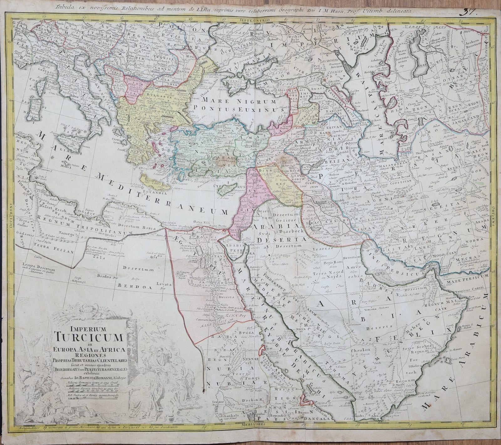
Imperium Turcicum in Europa, Asia et Africa regiones proprias tributarias clientelares sicut et omnes ejusdem Beglirbegatus seu Praefecturas Generales exhibens
HOMANN Heirs, after Johann Matthias Hase · Nuremberg · Homann Heirs · c. 1737
The Homann firm's map of the Ottoman Empire in Europe, Asia and Africa, drawn after De l'Isle and Johann Matthias Hase, from the Balkans and Egypt to Arabia, Persia and the Caspian; hand-coloured.
FM-0283
€ 450
All prices include VAT. Import duties outside the EU are not included.
Free insured shipping. The price shown is the price you pay.
Key Properties
Publisher: Homann, Nuremberg, after Guillaume de l'Isle and Johann Matthias Hase
Technique: Copper engraving, hand-coloured in outline and in part in wash
Plate number: 37 in the upper right corner
Region: the Ottoman Empire: the Balkans, Anatolia, the Levant, Egypt, Arabia, with Persia and the Caspian
Condition
Hand-coloured. Trimmed close to the border at the sides and the foot, as is the upper headline. Verso: the centrefold backed with a strip of paper; some spotting, light damp marks and small marginal tears and creases; light browning.
References & Bibliography
Sandler, Johann Baptista Homann, die Homännischen Erben, Matthäus Seutter und ihre Landkarten (1886-1890).
Tooley's Dictionary of Mapmakers, s.v. Hase, Johann Matthias.
Description
A large map of the Ottoman Empire at the height of its extent, coloured by province. It reaches from Italy and the Balkans in the west to Samarkand and the Persian Gulf in the east, and from Poland and the Crimea in the north to Nubia, Abyssinia and the Arabian Sea in the south. Each Ottoman beylerbeylik, from Bosnia, Bulgaria and Rumelia to Anatolia, Syria, Baghdad and Egypt, is distinguished in colour, with the tributary lands and the bordering states of Persia, Georgia and the Tatars. The Black Sea, the Caspian and the Red Sea are shown with their coasts and the caravan towns of Arabia, among them Mecca and Medina, are named.
The headline states that the map was drawn after the latest reports and according to De l'Isle, but above all after the celebrated geographer Johann Matthias Hase, professor at Wittenberg. The large title cartouche in the lower left is decorated with figures of Turks.
Historical Significance
Johann Matthias Hase (1684 to 1742), professor of mathematics at Wittenberg, drew many of the maps of Asia and Africa for the Homann firm in the 1730s and 1740s; this is one of the standard eighteenth-century maps of the Ottoman Empire.
Related works
Antique Maps · FM-0013
TOTIUS AMERICAE SEPTENTRIONALIS ET MERIDIONALIS NOVISSIMA REPRAESENTATIO
Johann Baptist Homann · Nuremberg · First state, c. 1710
€ 1.750
Antique Maps · FM-0014
ASIAE RECENTISSIMA DELINEATIO
Johann Baptist Homann · Nuremberg · probably c. 1716–1720
€ 800
All 3 works: Johann Baptist Homann →