Antique Maps
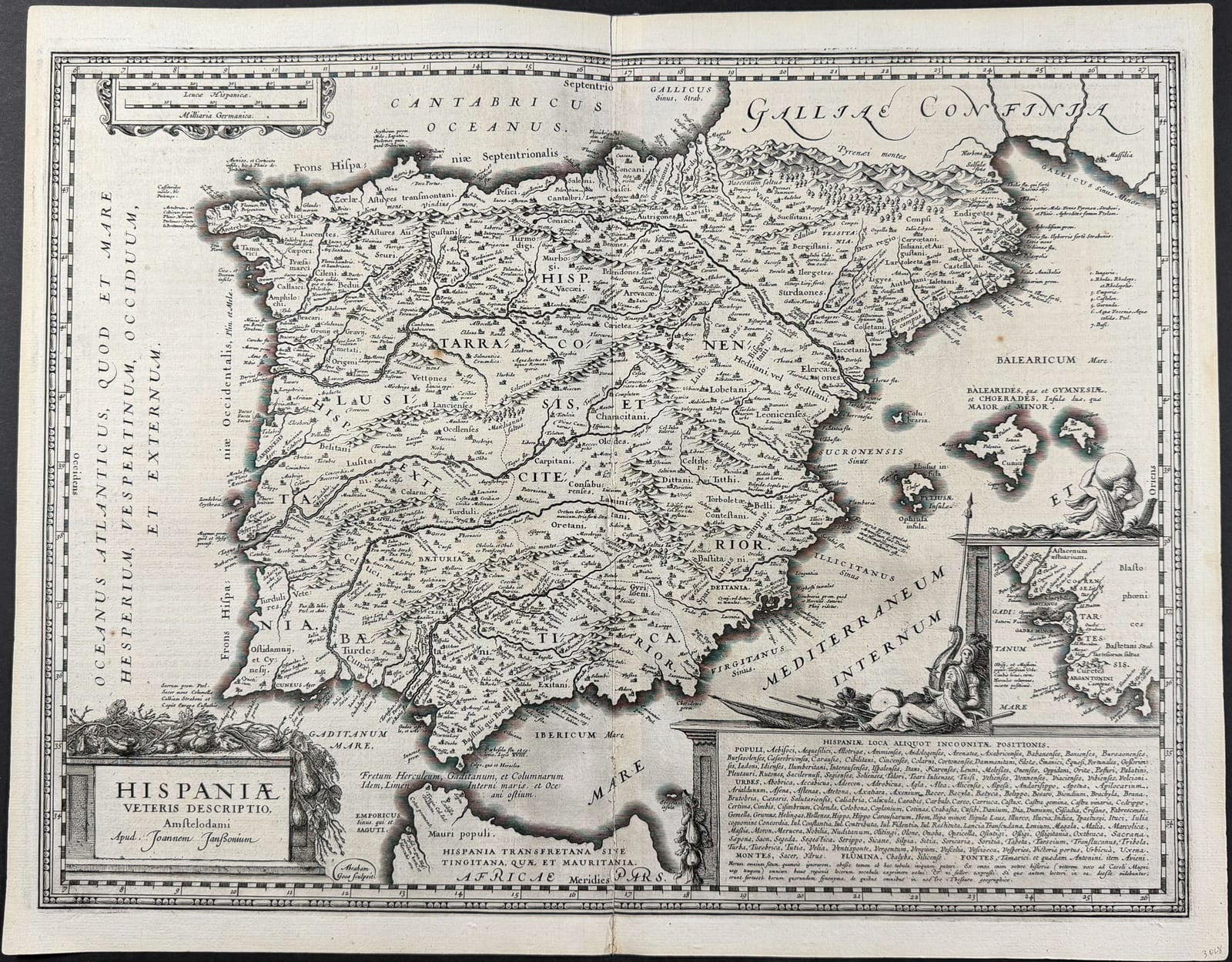
Hispaniae Veteris Descriptio (Ancient Spain and Portugal)
JANSSONIUS, Joannes (engraved by Abraham Goos) · Amsterdam · Joannes Janssonius · [1652 or later]
Janssonius's map of the Iberian peninsula in antiquity, engraved by Abraham Goos, from the Accuratissima Orbis Antiqui Delineatio, the atlas of the ancient world that formed the sixth volume of the Novus Atlas; a Latin-text issue, with old outline colour
FM-0176
€ 750
Key Properties
Edition: Janssonius, Accuratissima Orbis Antiqui Delineatio (Novus Atlas, vol. VI), Latin text edition, Amsterdam 1652 or later
Engraver: Abraham Goos (signed 'Abraham Goos sculpsit' in a cartouche at lower left)
Language: Latin, with Latin text on the verso (Hispania; signature SS)
Format: Copperplate engraving on laid paper, two conjoined leaves with the customary central fold
Sheet: approximately 40.5 x 52 cm
Colouring: Old outline colour
Collation & Technical Description
A single double-page sheet, the map engraved within a graduated border. Title in a cartouche at lower left, adorned with fruit and hanging trophies of arms: HISPANIAE VETERIS DESCRIPTIO. Amstelodami Apud Joannem Janssonium; engraver's signature 'Abraham Goos sculpsit' in a small cartouche below. The map shows the Iberian peninsula as it was in Roman times, divided into the provinces Tarraconensis, Lusitania and Baetica, with the ancient names of the peoples, towns, rivers and mountains, the Balearic islands, the Pyrenees with Galliae Confinia at the upper right, and the coast of North Africa (Hispania Transfretana sive Tingitana, quae et Mauritania, Africae Pars) at the foot; the seas lettered Oceanus Atlanticus, Cantabricus Oceanus and Mare Mediterraneum Internum. In the lower right a large cartouche with a reclining figure of Hispania in armour with spear and shield, above a panel listing HISPANIAE LOCA ALIQUOT INCOGNITAE POSITIONIS (peoples, towns, mountains, rivers and springs of uncertain location); to its right an inset of the Bay of Cadiz (Gades) with the estuary of the Baetis; scale of Leucae Hispanicae and Milliaria Germanica at upper left; the four cardinal points in the border. Latin text on the verso headed HISPANIA, with a large decorative initial, signature SS.
Condition
Very good condition. A good, clear impression with the old outline colour fresh; the customary central fold, with light offsetting from the text on the verso, some minor spotting and marginal marks; wide margins. Detailed condition report available on request.
References & Bibliography
Van der Krogt, Koeman's Atlantes Neerlandici, vol. I, the classical atlas of Janssonius (Accuratissima Orbis Antiqui Delineatio, 1652 and later editions). Ortelius, Parergon (Van den Broecke, Ortelius Atlas Maps, no. 193, Hispaniae Veteris Descriptio, 1586), the model for Janssonius's map. On the engraver: Abraham Goos (c. 1590 to 1643), Amsterdam engraver, who worked for Hondius, Janssonius and Blaeu.
Description
Janssonius's map of Spain and Portugal in antiquity, showing the Iberian peninsula as the Romans knew it: the three provinces of Hispania Tarraconensis, Lusitania and Baetica, with the ancient peoples (Cantabri, Astures, Callaici, Vaccaei, Celtiberi, Carpetani, Oretani, Turdetani and many others), the Roman towns, the rivers under their classical names (Iberus, Tagus, Anas, Baetis, Durius) and the mountain ranges, the Balearic islands and a strip of the North African coast. The map descends from the map of ancient Spain that Abraham Ortelius published in 1586 in the Parergon, the historical supplement to his Theatrum Orbis Terrarum, which was the first systematic atlas of the ancient world. Janssonius had his own version of the Parergon maps engraved on a larger scale and with the fuller and more decorative treatment of the mid-seventeenth century, and published them together as the Accuratissima Orbis Antiqui Delineatio, the atlas of ancient geography that appeared in 1652 and was thereafter issued as the sixth volume of his Novus Atlas, with text in Latin, Dutch, French and German.
The plate is signed by Abraham Goos, the Amsterdam engraver who worked for all the major map publishers of the city in the first half of the century and whose fine calligraphic lettering and pictorial mountains give the map much of its character. The two cartouches are typical of the Janssonius ancient-world atlas: at lower left the title framed by fruit and a trophy of Roman arms, at lower right the reclining figure of Hispania in armour, with a long list of places of uncertain location beneath her, a scholarly device that acknowledges the limits of ancient geography while filling the sea with text. The inset of the Bay of Cadiz, the ancient Gades with the mouth of the Baetis (Guadalquivir), draws attention to the most famous harbour of the ancient West and the traditional site of the Pillars of Hercules.
The present example has Latin text on the verso (Hispania, signature SS) and belongs therefore to one of the Latin editions of the atlas; it retains its old outline colour.
Historical Significance
The Janssonius atlas of the ancient world was, after Ortelius's Parergon, the most complete cartographic picture of antiquity available in the seventeenth century, and its maps remained in use for a century, the plates passing later to Schenk and Valk. The map of ancient Spain records the classical geography that underlay every educated European's idea of the peninsula, and is a fine example of the decorative Amsterdam engraving of the golden age.
Provenance
Available on request.