Antique Maps
Peru (the Viceroyalty of Peru, from Ecuador to northern Chile)
JANSSONIUS, Joannes · Amsterdam · Joannes Janssonius · c. 1640
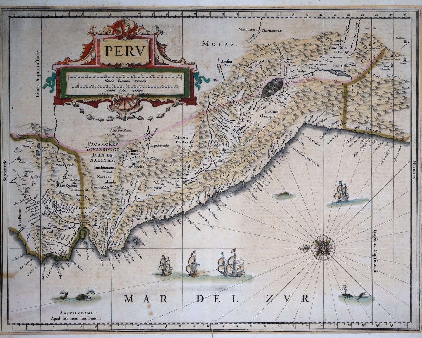
Janssonius's map of Peru, the viceroyalty from Quito to northern Chile, oriented with south at the top, from the Dutch text edition of the Novus Atlas, Amsterdam c. 1640, in original colour
FM-0184
€ 850
Key Properties
Edition: Joannes Janssonius, Novus Atlas (Nieuwe Atlas), Dutch text edition, Amsterdam, c. 1638 to 1647; Dutch text on the verso headed Het Coninckrijck Peru
Language: Latin map, Dutch text on the verso
Format: Copperplate engraving on laid paper, double-page atlas sheet with the customary central fold
Orientation: South at the top, the Pacific (Mar del Zur) at the right
Colouring: Original colour
Collation & Technical Description
A double-page map of the Viceroyalty of Peru from the Linea Aequinoctialis (the Equator) at the foot to the Tropic of Capricorn at the top, thus oriented with south at the top: the Andes and the Pacific coast from Quito and Cuenca by way of Lima (Los Reyes) and Cuzco to Arequipa, Arica and the northern coast of Chile, the highlands with Lake Titicaca and the province of Los Moxos (Moias) to the left, the Mar del Zur to the right with four ships under sail, whales and a large compass rose. The title PERV in a strapwork cartouche with the scale of miles, the imprint Amstelodami apud Ioannem Ianssonium at the upper right (as read with south up). The Spanish provinces and the Inca roads named; Pacamoros, Yvarasongo and Iuan de Salinas in the Amazonian foothills. Verso: Dutch text headed Het Coninckrijck Peru, describing Cuzco, Quito and the conquest by Francisco Pizarro.
Condition
A good impression in original colour, the outline and wash colouring fresh. Customary central fold; light age-toning, a few small spots and a little soiling in the margins.
References & Bibliography
Van der Krogt, Koeman's Atlantes Neerlandici, I (Mercator, Hondius, Janssonius). Tooley, The Mapping of America. Cf. the example in the Huntington Library.
Description
Janssonius's map of Peru is one of the two standard Dutch folio maps of the viceroyalty in the golden age of Amsterdam cartography, the rival of the Blaeu map of the same subject. Both go back to the work of Hessel Gerritsz, hydrographer of the East and West India Companies, whose map of Peru of 1625 drew on the Spanish chronicles, above all Cieza de León, and on the reports of the Dutch expeditions to the Pacific coast. When Blaeu acquired the Hondius plate of Peru in 1629 and issued it under his own name, Janssonius, Hondius's brother-in-law and successor, had a new plate cut for his own atlas, and it is that plate which is printed here.
The map is oriented with south at the top, so that the Pacific, the Mar del Zur, lies to the right and the Andes run across the sheet. It covers the viceroyalty from Quito to the coast of Chile, with Lima, the City of the Kings, Cuzco, the old Inca capital, Potosí's neighbours in the highlands and Lake Titicaca, and it names the Spanish corregimientos and the Indian provinces of the Amazonian slopes. Four ships, spouting whales and a fine compass rose fill the sea, and the strapwork cartouche carries the title and the scale.
The present example comes from a Dutch text edition of Janssonius's atlas, with the description Het Coninckrijck Peru on the verso, and is in original colour.
Historical Significance
Peru was the treasure house of the Spanish empire, and the silver of Potosí that passed through Lima and the Mar del Zur was the prize the Dutch fleets of Spilbergen, l'Hermite and Brouwer sailed round Cape Horn to intercept. For the Amsterdam public of the 1640s this map was the picture of that coast, made in the city that financed the attacks on it.
Provenance
Available on request.