Antique Maps
Oceanus Aethiopicus
HULSIUS, Levinus · Levinus Hulsius · 1602
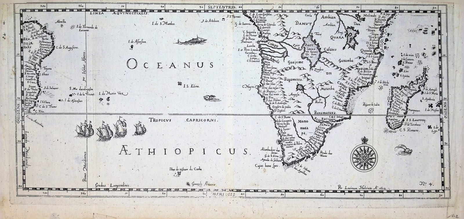
Levinus Hulsius's chart of the South Atlantic, signed and dated 1602: eastern Brazil, the islands of the ocean and southern Africa from the Congo to Mozambique and Madagascar, on the route of the Dutch fleets to the East Indies.
FM-0268
€ 575
All prices include VAT. Import duties outside the EU are not included.
Free insured shipping. The price shown is the price you pay.
Key Properties
Date: signed and dated in the plate "Per Leuinum Hulsium A° 1602"
Plate number: No. 4
Technique: Copper engraving, uncoloured
Size: c. 18.5 x 39.5 cm
Region: South Atlantic Ocean, eastern Brazil, southern Africa, Madagascar
Condition
Good overall, with light discolouration and some old marks. The engraving is legible throughout, with small areas at the lower centre and the middle left harder to read. Verso blank, with paper strips along the centrefold and at the plate edges; pencil and ink numbers.
Description
A small but crowded chart of the South Atlantic, signed and dated in the plate "Per Leuinum Hulsium A° 1602" and numbered 4. It runs from the equator to the latitude of the Cape and from the coast of Brazil, with Pernambuco, Cabo de Santo Agostinho and Salvador, across the ocean to Africa and Madagascar. The Atlantic islands are all there: Fernando de Noronha, Ascension, St Helena, Trindade and Martim Vaz, Tristan da Cunha and Gonçalo Álvares. On the African side the map names the coast from Cabo Lopo Gonçalves past the Congo and Angola to the Cape of Good Hope and Cape Agulhas, and up the east coast to Monomotapa, Mozambique, Mombasa and Melinde, with the great lake "Zaire lacus ubi Syrenes esse dicuntur" in the interior. Ships under sail cross the Tropic of Capricorn, and sea creatures and a compass rose fill the ocean.
Levinus Hulsius (c. 1550-1606), born in Ghent, published from 1598 a German collection of voyages, the Schiffahrten, which eventually ran to twenty-six parts. Its early parts followed the first Dutch voyages to the East Indies, for which this was the sea to be crossed.
Historical Significance
The chart shows the South Atlantic as the Dutch had just come to know it: the ocean between Brazil and the Cape that every fleet to the East had to cross, with the islands where ships took on water and the Portuguese names that still covered both coasts.
Related works
Voyages & Discovery · FM-0022
Grands Voyages & Petits Voyages, The Complete De Bry
Theodor de Bry (1528–1598) and sons Johann Theodor & Johann Israel de Bry · Frankfurt · 1590–1634
Price on request
Voyages & Discovery · FM-0044
Begin ende Voortgangh van de Vereenighde Nederlantsche Geoctroyeerde Oost-Indische Compagnie
Isaac Commelin (compiler and editor) · Amsterdam · 1646
Price on request
Voyages & Discovery · FM-0030
Oost-Indische voyagien
Joost Hartgers (collector & printer); various authors · Amsterdam · 1648
Price on request
Voyages & Discovery · FM-0033
Spieghel der Australische navigatie
Jacob le Maire; Antonio de Herrera; Pedro Ordóñez de Ceballos · Amsterdam · 1621–1622
€ 35.000
All 34 works: The Dutch East India Company (VOC) →