Voyages & Discovery
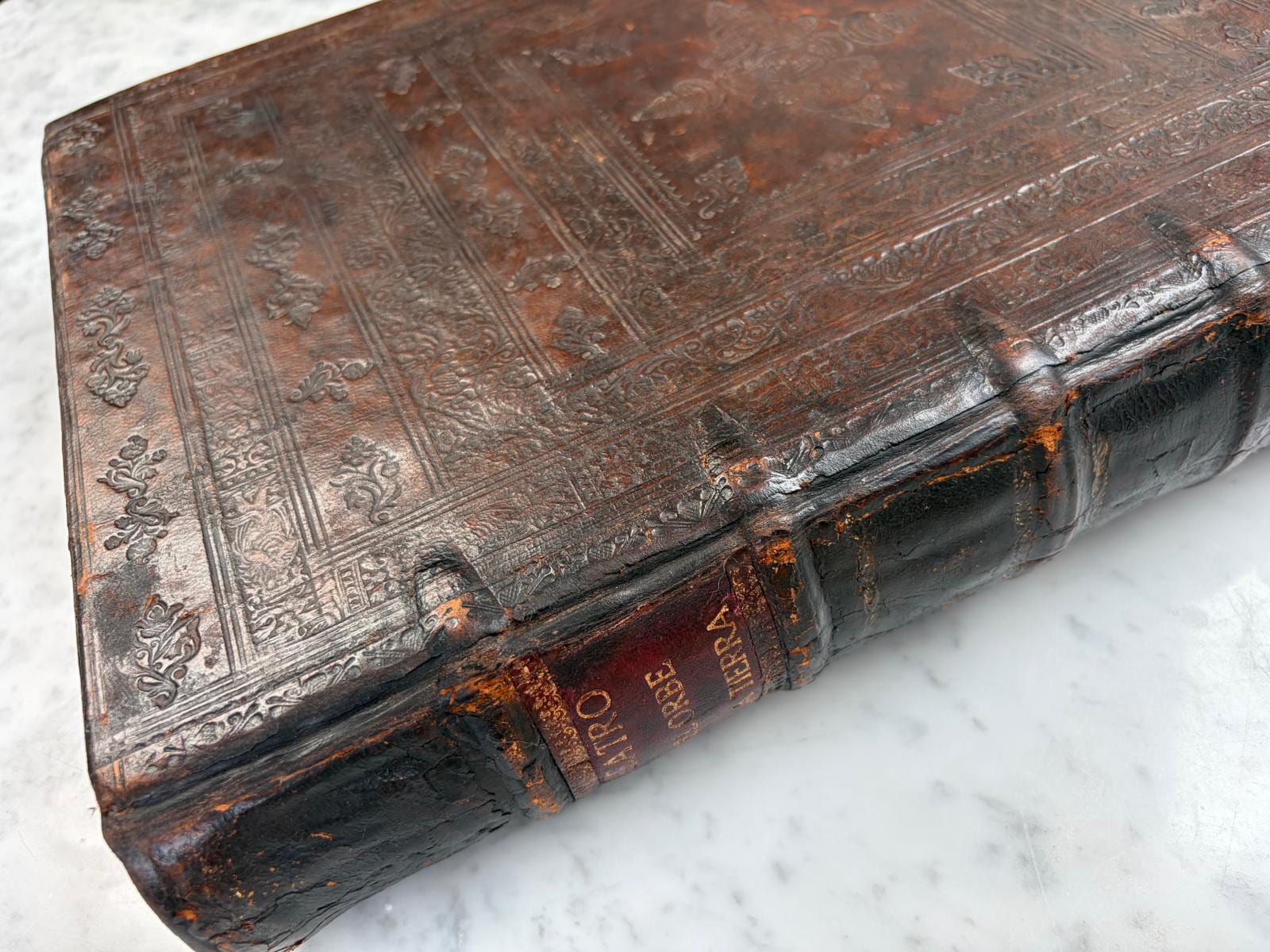
Theatro d'el Orbe de la Tierra
Abraham Ortelius (1527–1598) · Officina Plantiniana, Balthasar II Moretus · 1641
The last edition of Ortelius's Theatrum ever published: Spanish text, Antwerp, Officina Plantiniana, 1641, 127 maps
FM-0025
Price on request
Key Properties
Edition: Last edition of the Theatrum ever published; without
Language: Spanish text; Latin map titles and scales
Format: Large folio atlas
Binding: Contemporary calf, restored spine
Collation & Technical Description
Complete with 127 engraved double-page maps with Spanish text, without the Parergon (not called for by Van der Krogt). Engraved architectural title page with the Plantin device framing the Spanish Theatro imprint. The section Cartas Nuevamente Añadidas en Este Theatro survives and appears integral to the volume. Letterpress title imprint (printed with separate copperplate, as transcribed by Van der Krogt, 31:454): THEATRO | D’EL ORBE | DE LA TIERRA | DE ABRAHAM ORTELLO. | El qual antes el estremo dia | de su vida postrera vez | ha emendado, y con nueuas | Tablas y Commentarios | augmentado y esclarescido. EN ANVERES, | SE VENDE EN LA LIBRERIA PLANTINIANA, | M.DC.XII. The Spanish contents table is internally coherent. Portugal is present. Pagination continues correctly throughout. Latin map titles and scales are retained on the maps, with Spanish commentary and indexes on the versos. No evidence was found for missing maps or gatherings based on the examined foliation and contents. Full-size atlas with strong impressions. Ortelius's characteristic strapwork cartouches, sailing ships and sea creatures animate the maps throughout. Minor fold wear on approximately ten maps, slight colour bleed on two maps, and a small marginal loss to the Ireland map. Title remargined.
Condition
Contemporary calf binding with restored spine. The atlas is full-size with wide margins, indicating that it has not been trimmed. The maps are beautifully handcoloured throughout in later lege artis colour, applied with period-appropriate pigments and technique that enhance the engraved detail without obscuring it. The impressions are strong and well-printed. Minor fold wear is present on approximately ten maps, consistent with a working atlas of this scale and age. Slight colour bleed is visible on two maps. The Ireland map has a small marginal loss. The title page has been remargined. Overall: a fine, complete example of the last Spanish edition of the Ortelius atlas, with a materially positive condition report for a work of this scale and importance.
References & Bibliography
Koeman, Cornelis. Atlantes Neerlandici. Reference: Ort 43. Van der Krogt, Peter. Koeman’s Atlantes Neerlandici, New Edition, Vol. IIIA. Reference: 31:454. Ortelius section. Van den Broecke, Marcel. Ortelius Atlas Maps. Essential reference for plate states and the concept of 'unstable editions.' Schilder, Günter. Monumenta Cartographica Neerlandica. On Dutch atlas and map production. Karrow, Robert W. Mapmakers of the Sixteenth Century and their Maps. Imhof, Dirk (1999). Cited by Van der Krogt (31:454) as the reference for the production history of the 1641 Spanish printing at the Officina Plantiniana. Lissens, J. Paul (ed.). De Nottebohmzaal: Boek en Mecenaat. Antwerp: Stad Antwerpen, 1993, no. 23. On the Antwerp presentation copy and its binding. Catálogo Colectivo del Patrimonio Bibliográfico Español (CCPB); Biblioteca Digital Hispánica, BNE (bdh0000000701). Spanish heritage records of the Theatro under the year 1612, without distinction of map states.
Description
A complete Spanish-language issue of Ortelius's Theatrum Orbis Terrarum, comprising 127 engraved maps with Spanish text, without the Parergon (not called for by Van der Krogt). Printed at the Officina Plantiniana by Balthasar II Moretus in 1641, this is the absolute last edition of the Theatrum Orbis Terrarum ever published, marking the endpoint of the most successful atlas in European publishing history.
Abraham Ortelius died in 1598. The copperplates and rights to the Theatrum passed first to the Antwerp publisher Jan Baptist Vrients, and upon Vrients's death in 1612 were acquired by the Plantin-Moretus press. Although by 1641 Ortelius's maps had been partly superseded by the more modern atlases of Blaeu and Hondius, the Moretus press nevertheless chose to print one final, monumental Spanish luxury edition for the southern European and Spanish-speaking market.
On 11 May 1641 Jan Galle was paid for printing 25 copies of each of the 138 plates for this Spanish edition (Van der Krogt 31:454); the 1642 estate inventory of Balthasar Moretus still listed 22 copies with the plates and 160 copies of the Spanish text without maps. The copperplates, by then decades old, occasionally show signs of wear or repair compared with the earliest sixteenth-century impressions.
The atlas preserves a panorama of sixteenth-century geographical knowledge. Among the 127 maps are depictions of mythical islands in the Arctic, an oversized southern continent, the cities of gold in California, Japan in the middle of the Pacific, and a Northwest Passage near Greenland, reflecting the geographical imagination of an era when the boundaries between the known and unknown world were still being drawn.
This copy is of particular bibliographical interest. As a 1641 printing from copperplates that had been in continuous use since the 1570s–1590s, it combines early and late plate states within a coherent and internally consistent atlas structure, documenting the practical production methods of the Plantin-Moretus workshop across seven decades.
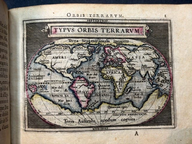
The world map (Typus Orbis Terrarum) and the America map (Americae Sive Novi Orbis Nova Descriptio) both contain Fretum Le Maire, indicating post-1616 geographical updates, the Strait of Le Maire was discovered during the expedition of Jacob Le Maire and Willem Schouten in 1615–1616. At the same time, Maris Pacifici retains an earlier state without Le Maire. The atlas also contains the earlier Italy plate (Van den Broecke 117, with the inscription 'Servia') rather than the later plate 118. Van den Broecke explicitly records encountering this earlier plate in a Spanish 1612S edition, confirming that older copperplates remained in use during the final production phase.
This combination of states accords with Marcel van den Broecke's concept of the 'unstable editions' of the late Ortelius atlases: Plantin-Moretus used available copperplates simultaneously, some updated, others retained in their earlier state. Rather than a deficiency, this mixed-state configuration enhances the scholarly significance of the volume, documenting the transition from older to newer geographical knowledge within a single atlas.
Van der Krogt's published collation of the 1641 issue (31:454) documents the workshop revisions in detail. The new issue contains more than 60 updated and revised maps, while the letterpress texts remain identical to those of the 1612 edition. In the 1620s Theodorus Galle (1571–1633) added his name to ten maps (23, 38–42 and 45–48). His son Johannes Galle subsequently removed the engraved dates from some thirty maps; added or altered border co-ordinate numerals on nine maps; erased his father's name from maps 45 and 48; altered the topography of map 49; and added his own imprint, undated on map 32, dated 1640 on maps 19 and 47, and dated 1641 on map 22. On some maps in the located copies Johannes Galle's name was covered with a strip of paper during printing. These documented revisions provide objective diagnostics for recognising the 1641 issue.
Historical Significance
Ortelius's Theatrum Orbis Terrarum, first published in 1570, is universally regarded as the first modern atlas. For the first time, a publisher assembled a uniform set of maps on consistent sheets, accompanied by descriptive text, and issued them as a single, coherent book. This concept, so familiar to us today, was revolutionary in its time and established the format that would be followed by Mercator, Blaeu, Hondius and every atlas publisher thereafter.
Abraham Ortelius (1527–1598) was an Antwerp cartographer, geographer and antiquarian who assembled the geographical knowledge of an entire era. His atlas went through over forty editions in multiple languages between 1570 and 1641, continually updated with new maps as geographical discoveries expanded European understanding of the world.
The present copy is the final chapter of this tradition. In 1641, forty-three years after Ortelius's death, Balthasar II Moretus printed one last Spanish luxury edition from the original copperplates, which had passed from Ortelius to Vrients (d. 1612) and thence to the Plantin-Moretus press. By this date, the atlases of Blaeu and Hondius had overtaken Ortelius in geographical accuracy, yet the Theatrum retained its prestige and commercial appeal, particularly in the Spanish-speaking world. This 1641 edition is the absolute endpoint of a publishing enterprise that had begun over seventy years earlier.
The Spanish-language edition is of particular significance. Spain was the dominant global power of the sixteenth century, and Spanish navigators, explorers and administrators were the primary consumers of geographical knowledge about the Americas, the Pacific, and the routes to the East. A Spanish Ortelius atlas was not merely a scholarly reference, it was a practical tool of empire.
Complete copies of the 1641 Spanish edition are exceptionally rare. Only 25 copies of the maps were printed in 1641, and Spanish copies with maps were always scarce: Vrients's estate had recorded just 19 Spanish copies with maps against 220 without. Many surviving examples have been broken up for the sale of individual maps or have lost maps over the centuries. A complete copy in its contemporary binding, with full margins, strong impressions, and beautifully applied later lege artis colouring, represents a major opportunity for collectors and institutions alike.
Van der Krogt's published census (31:454) records only two located copies of this final issue: the copy presented by Balthasar II Moretus to the town of Antwerp, still in the city's library (Antwerpen SB, K 6172, bound with the 1624 Parergon in a gold-stamped presentation binding with the arms of Antwerp), and the copy in the Newberry Library, Chicago (Ayer 135 O7 1612, without Parergon). Both include maps dated 1641. The rarity profile is corroborated by David Weimer, curator at the Newberry Library (correspondence, 2026).
The Spanish bibliographic heritage records illustrate the identification problem. The Catálogo Colectivo del Patrimonio Bibliográfico Español (CCPB) and the Biblioteca Nacional de España record Spanish copies of the Theatro simply under the year 1612, the BNE copy (digitised in the Biblioteca Digital Hispánica, bdh0000000701) carries no indication of map states. None of these records distinguishes map states or notes maps dated 1640–1641; only direct collation of the maps can establish whether a Spanish '1612' copy is in fact the 1641 issue.
Provenance
Early Spanish ownership inscription of Josef Navarro, with a preceding manuscript phrase that represents a possible ecclesiastical gift formula. The strongest working interpretation of the accompanying inscription is an archaic Spanish phrase close to Diole el Padre or Diolo el Padre, in modern terms: 'the father/priest gave it to him.' The hand appears compatible with early Spanish ownership, probably seventeenth or eighteenth century. A gift or transfer formula involving 'Padre' suggests ecclesiastical circulation: a priest, religious house, college, seminary or clerical owner may have transferred the atlas to Josef Navarro. This provenance is consistent with the Spanish edition and gives the copy a specific historical identity.
The Spanish ecclesiastical provenance is particularly fitting for this edition. The Catholic Church and its religious orders were among the most important institutional consumers of geographical knowledge in the Spanish world, maintaining libraries that served both scholarly and administrative purposes across the vast Spanish colonial empire.
Related works
Voyages & Discovery · FM-0031
Epitome du theatre du monde
Abraham Ortelius · Antwerp · 1588
€ 11.000
Antique Maps · FM-0124
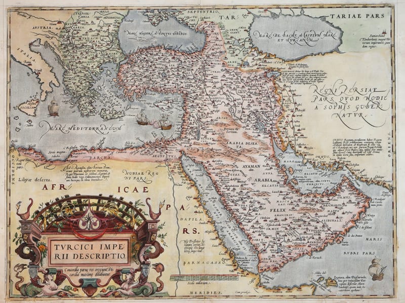
Turcici Imperii Descriptio (The Ottoman Empire), first plate
ORTELIUS, Abraham · Antwerp · 1571
€ 1.950
Antique Maps · FM-0180
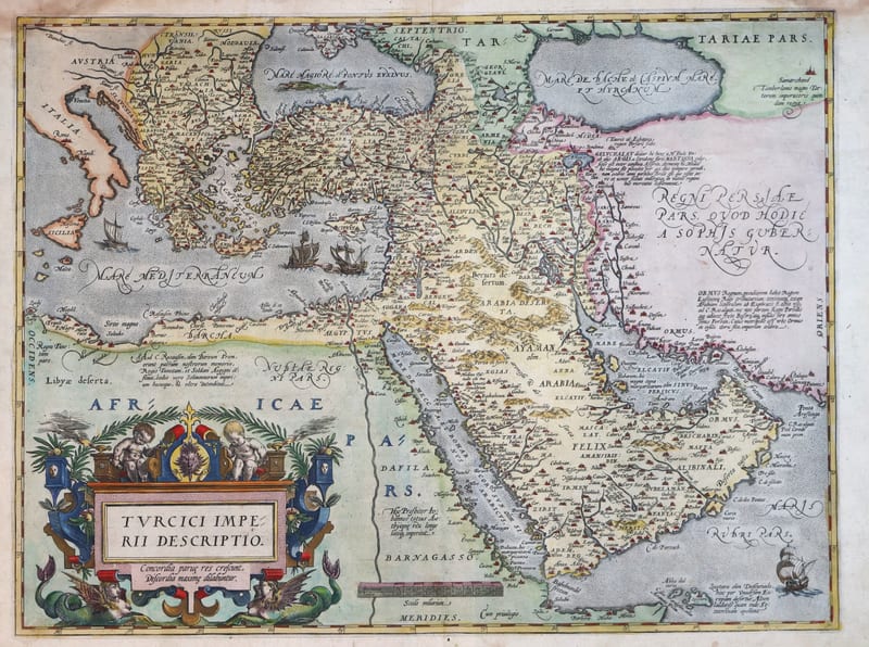
Turcici Imperii Descriptio (The Ottoman Empire), second plate, Spanish edition
ORTELIUS, Abraham · Antwerp · 1588
€ 1.500
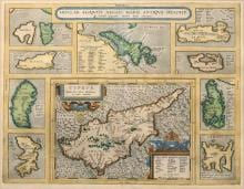
Antique Maps · FM-0015
INSULAR. ALIQUOT AEGAEI MARIS ANTIQUA DESCRIP.
Abraham Ortelius · Antwerp · Copperplate first issued 1584; later Latin-text example
€ 1.200
All 9 works: Abraham Ortelius →