Cartography
Isolario di Benedetto Bordone, de tutte l'Isole del mondo
Benedetto Bordone · Venice · Nicolò d'Aristotile, called Zoppino · 1534
Benedetto Bordone's Isolario, the first atlas to portray the whole world as a sequence of islands, in the second edition of 1534: with the oval world map, the first printed map of Japan, the earliest printed map devoted to North America, the plans of Venice and Tenochtitlan, and the first printed report of Pizarro's conquest of Peru
FM-0037
€ 20.000
Key Properties
Edition: Second edition, Venice, Nicolò d'Aristotile called Zoppino, June 1534 (first edition 1528; later editions 1547 and about 1565)
Language: Italian
Format: Folio
Contents: title within a woodcut border printed in red and black, a full-page diagram of the winds, three double-page maps (the world, Europe with North Africa, the Aegean), the double-page bird's-eye plan of Venice, four double-page island maps (Crete, Euboea, Cyprus, Sicily), the plan of Tenochtitlan (Mexico City) and about a hundred smaller woodcut maps set in the text; at the end the letter on the conquest of Peru
Binding: Nineteenth-century quarter vellum
Collation & Technical Description
10 nn. lvs; 74 folios. Title within engraved scrolls printed in red and black.
Condition
A good copy; full condition report on request.
References & Bibliography
Sabin 6419. Harrisse, Bibliotheca Americana Vetustissima, 187. Shirley, The Mapping of the World, 59; Shirley, British Isles, 19. Burden, The Mapping of North America, 8. Suarez, Shedding the Veil, pp. 66 to 67. Ginsberg, Printed Maps of Scandinavia and the Arctic, 7. Adams B2482. Mortimer, Harvard Italian, 82. Borba de Moraes, I, p. 98.
Description
Benedetto Bordone (Padua 1460 to Venice 1531) was a miniaturist and woodcut designer who spent his working life in Venice, where the Senate granted him a privilege to print maps in 1508. His Isolario, first published by Zoppino in 1528, is the only work of his to survive and the book on which his fame rests: the first printed atlas to present the entire known world as a sequence of islands, from the Atlantic and the Caribbean by way of the Mediterranean and the Aegean to the Indian Ocean and Japan. The island book, or isolario, was a Venetian genre that grew out of the portolan charts and the pilgrim routes of the Levant; its first printed representative, the Isolario of Bartolomeo dalli Sonetti of about 1485, was confined to the Aegean. Bordone was the first to extend the idea to the whole globe, adding a few general maps to place his islands: the world, Europe, the Aegean.
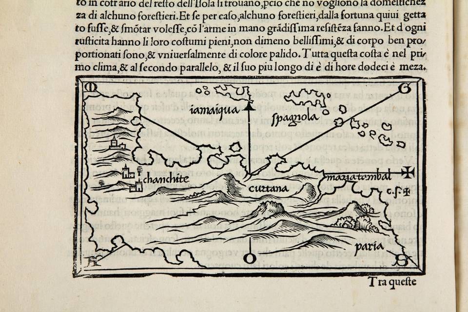
The present second edition of 1534 is the one collectors prefer. It contains all the celebrated woodcuts of 1528, several of them milestones in their own right. The double-page world map is one of the earliest printed maps on an oval projection, the form later taken up by Ortelius. The small map of Terra de Lavoratore has been shown by Thomas Suarez to represent the whole of North America, which makes it the first printed map devoted to that continent; with the map of Paria beside it, the book offered as early as 1528 an image of the entire American landmass. The map of Ciampagu is the earliest printed map of Japan, drawn from Marco Polo's account long before any European had set foot there in 1543. There are early maps of Cuba, Jamaica and Hispaniola, of Cyprus, Crete, Ireland and Scandinavia, and two famous city plans: the bird's-eye view of Venice, among the earliest printed plans of the city, and the plan of Tenochtitlan on its lake, derived from the map published with Cortés's second letter at Nuremberg in 1524 and showing the Aztec capital as it was before its destruction.
What distinguishes the edition of 1534 from the first is the leaf added at the end: the Copia delle lettere del prefetto della India, a letter reporting Pizarro's conquest of Peru and his victory over the Inca Atahualpa in 1533, one year before the book appeared. It is the first edition of one of the earliest printed accounts of the conquest of Peru, and it gives the Isolario its place in the Americana of the conquest as well as in the history of cartography.
Historical Significance
The Isolario stands at the point where the medieval island book of the Mediterranean pilot became the modern atlas. Bordone's oval world, his islands of the new ocean sea and his plan of Tenochtitlan gave the Venetian public, in the decade after Magellan, a picture of a world made of islands and coasts that could be sailed between, and the book was a direct precursor of the world atlases of Ortelius and Mercator forty years later. The 1534 edition adds to that the first news in print of the fall of the Inca empire, so that the same volume records the two great Spanish conquests of the century, Mexico in a map and Peru in a letter.
Provenance
Available on request.